The campaign will be implemented under the NASA-funded Earth Venture airborne mission, DISCOVER-AQ (Deriving Information on Surface Conditions from Column and Vertically Resolved Observations Relevant to Air Quality). The campaign will employ NASA aircraft to make a series of flights, with scientific instruments on board to measure gaseous and particulate pollution, beginning in July 2011 in the Baltimore-Washington metropolitan area. The series of flights will be made by NASA Langley's King Air and NASA's P-3B. The measurements will be taken in concert with ground observations in order to shed light on how satellites could be used to make similar, consistent measurements over time, with the ultimate goal of putting better data in the hands of policymakers and elected officials. DISCOVER-AQ is a collaboration among scientists at NASA’s Langley Research Center in Hampton, Va.; NASA’s Goddard Space Flight Center in Greenbelt, Md.; NASA’s Ames Research Center, outside San Francisco; and multiple universities. DRAGON will be a significant part of the ground-based aerosol measurement program.
In addition to DISCOVER-AQ collaborators, AERONET will participate with the following groups:
WeatherBug Networks/Earth Networks: Establish approximately 30 AERONET sites co-located with school based WxBug automatic weather station sites. Ten to twenty more AERONET sites will be located in the region to complete the mesoscale gridded network of sun photometers.
Ihab Abboud-AEROCAN: Canadian affiliate, Environment Canada, contributing approximately 15 AERONET sites to DRAGON.
Philippe Goloub-PHOTONS: French AERONET affiliate will provide polarized sun photometer, car mounted mobile sun photometer and lidar system.
The network is planned for six weeks of operation over the Washington DC-Baltimore metropolitan area from July 1 to August 15, 2011. The network will be strategically located to take advantage of DISCOVER AQ in situ and airborne resources, see Figures 1 and 2.
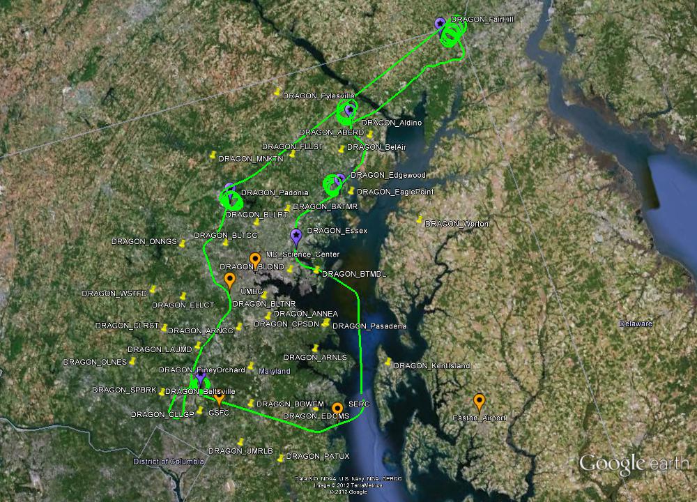
Figure 1 shows the AERONET sites (yellow AERONET/WxBug and purple AERONET/DISCOVER AQ and orange long term AERONET sites). Download KMZ file for Figure 1.
DRAGON Text Lists
+ Level 1.0 AOD Data (TXT)
+ Level 1.5 AOD Data (TXT)
+ Level 2.0 AOD Data (TXT)
DRAGON Google Earth Distribution
+ Level 1.0 AOD Data (Google Earth KMZ)
+ Level 1.5 AOD Data (Google Earth KMZ)
+ Level 2.0 AOD Data (Google Earth KMZ)
|


