|
|
 |
| |
| Cloud Mode |
| |
The “cloud-mode” (or the zenith-pointing of the Cimel Electronique sun/sky radiometer) is a newly activated capability of AERONET. This measurement technique has the potential to inexpensively yet dramatically increase global coverage of ground-based cloud observations. AERONET is comprised of over 400 narrow field-of-view sun/sky radiometers, which normally provides measurements of aerosol properties. However, when clouds block the sun, AERONET radiometers are put to sleep because a generally cloud-free sky between the instrument and top of the atmosphere is needed to retrieve aerosol properties. The cloud-mode capability takes advantage of instrument idle time by performing 10 zenith radiance measurements at 9-second intervals for the 440 and 870 nm wavelengths (Fig. 1). These radiance measurements in conjunction with spectral surface albedo can retrieve cloud optical depth primarily over vegetated surfaces (NDVI >0.3). The enabling of this capability inaugurates the first extensive ground-based global dataset of cloud optical depth, a crucial parameter for climate models.
Instructions to Enable Cloud Mode |
|
Cloud Mode Publications |
| |
Main reference:Chiu, J. C., C.-H. Huang, A. Marshak, I. Slutsker, D. M. Giles, B. N. Holben, Y. Knyazikhin, and W. J. Wiscombe, 2010: Cloud optical depth retrievals from the Aerosol Robotic Network (AERONET). J. Geophys. Res., 115, D14202, doi:10.1029/2009JD013121. [Full Text (PDF)]
|
| |
Additional references:
Chiu, J. C., A. Marshak, Y. Knyazikhin, W. J. Wiscombe, H. W. Barker, J. C. Barnard, and Y. Luo, 2006: Remote sensing of cloud properties using ground-based measurements of zenith radiance. J. Geophys. Res., 111, D16201, doi:10.1029/2005JD006843. [Full Text (PDF)]
Marshak, A., Y. Knyazikhin, K. Evans, and W. Wiscombe, 2004: The "RED versus NIR" plane to retrieve broken-cloud optical depth from ground-based measurements. J. Atmos. Sci., 61, 1911-1925. [Full Text (PDF)] |
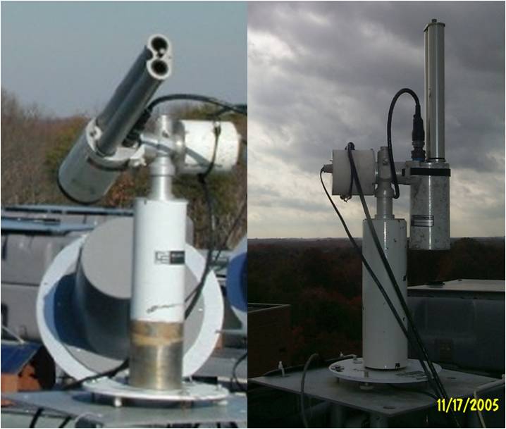
Fig. 1: An AERONET sunphotometer operating in normal sun-seeking aerosol mode (left) and zenith-pointing cloud mode (right).
Retrieval method
Cloud optical depth (COD) retrievals are based on the underlying physical principle that clouds have nearly identical optical properties at 440 and 870 nm wavelengths, while vegetated surfaces reflect much more at 870 nm than at 440 nm. Figure 2 shows the relationship between zenith radiances and surface reflectance to COD and cloud fraction. The curvilinear grid corresponds to COD (or tc)ranging from 0 to 90 and to effective cloud fractions (Ac) ranging from 0.2 to 1.0. Red dots are sample AERONET cloud-mode data points. By interpolating data points to the curvilinear grid, both tc and Ac can be retrieved simultaneously using a table lookup scheme. In the current cloud-mode version, only COD is reported; effective cloud fraction will be provided later. For more details about the retrieval method, click here.
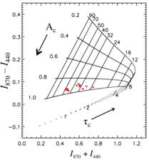
Fig. 2: The difference vs. the sum of zenith radiances at 870 and 440 nm wavelength. Model-generated curvilinear grid assumes a cloud effective radius of 8 μm and solar zenith angle of 58°. Surface albedo is 0.06 at 440 nm and and 0.40 at 870 nm. Curves represent various CODs (tc) and effective cloud fractions (Ac). Red dots are data points taken from AERONET cloud-mode operation at the ARM Oklahoma site on 20 January 2006.
Potential Sites
To ensure the reliability and stability of COD retrievals, cloud-mode sites have been chosen based on spectral contrast in surface reflectance between 440 and 870 nm, which are evaluated using a normalized difference vegetation index (NDVI). Figure 3 shows the location of 71 potential cloud-mode sites using the criterion in which NDVI around the site was greater than 0.3 for 95% of the time during 2005–2008. These designations are intended to initially identify existing sites that will obtain maximum information content from the cloud-mode retrievals; however, principal investigators and site managers are welcome to make further recommendations for cloud-mode sites.
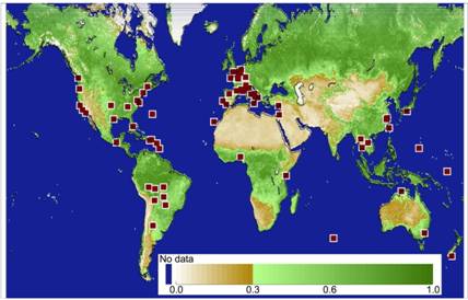
Fig. 3: Normalized difference vegetation index (NDVI) from MODIS/Aqua measurements during 18 June – 3 July 2007. Red dots show AERONET sites where 95% of NDVI values were greater than 0.3 for years 2005 – 2008. Note that only AERONET sites operated in both year 2007 and 2008 are considered here.
Quality Levels
Quality levels of cloud-mode retrievals for COD are: 1.0, 1.5 or 2.0. Level 1.0 COD product uses the pre-field deployment calibration and surface albedo estimates from the optimized climatological database. Level 1.5 COD product is similar to Level 1.0 COD, except that Level 1.5 COD uses the surface albedo from the MODIS collection 5 products (MCD43B1). Due to the provisional nature of this product, Level 2.0 data are not available. In the future, a Level 2.0 COD product will be available after applying pre- and post- field calibration and MODIS surface albedo estimates.
Deployment Recommendations
To ensure quality of measurements for both aerosols and clouds, site managers are encouraged to evaluate the status of wet sensors on a routine basis. Particularly, site mangers should verify wet sensors work properly during precipitation periods.
|
