|
|
 |
| |
| OCEAN COLOR |
| |
| |
The Aerosol Robotic Network (AERONET), developed to sustain atmospheric studies at various scales with measurements from worldwide distributed autonomous sun-photometers has been extended to support marine applications. This new network component called AERONET – Ocean Color (AERONET-OC), provides the additional capability of measuring the radiance emerging from the sea (i.e., water-leaving radiance) with modified sun-photometers installed on offshore platforms like lighthouses, oceanographic and oil towers. AERONET-OC is instrumental in satellite ocean color validation activities through standardized measurements a) performed at different sites with a single measuring system and protocol, b) calibrated with an identical reference source and method, and c) processed with the same code.
A complete description of the methods and algorithms used to produce the normalized water leaving radiance are detailed in Zibordi et al. (2009: AERONET-OC: A Network for the Validation of Ocean Color Primary Products. J. Atmos. Oceanic Technol., 26, 1634–1651, DOI: 10.1175/2009JTECHO654.1." This paper is available at the AERONET Ocean Color Publications web page.
|
| |
| System Description |
| |
| |
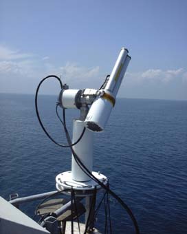
Recent developments in above water radiometry (Mobley 1999, Hooker et al. 2002, Zibordi et al. 2002) led to the development of a fully autonomous above-water radiometer system (Zibordi et al. 2004). This is based on the extended capability of CIMEL (Paris, France) CE-318 automated sun-photometers to perform marine radiometric measurements for determining the spectral Normalized Water-Leaving Radiance, Lwn(λ), in addition to the regular measurements for retrieving aerosol optical properties. This CIMEL-based system, called SeaWiFS Photometer Revision for Incident Surface Measurements (SeaPRISM), performs multiple sky- and sea-radiance measurements at programmable viewing and azimuth angles at eight (nine in the most recent instrument release) center-wavelengths in the 400-1020 nm spectral range.
The most recent SeaPRISM system configuration performs ocean color measurements at the 400, 412.5, 442.5, 490, 510, 560, 620, 665, and 667 nm center-wavelengths. Additional measurements are performed at 709, 865, and 1020 nm for quality checks, turbid water flagging, and for the application of alternative above-water methods (Zibordi et al. 2002). These center-wavelengths and additionally that at 940 nm were selected to guarantee basic AERONET atmospheric aerosol and water vapor monitoring capabilities and to support essential validation activities for current ocean color EO systems
|
| |
| Deployment Recommendations |
| |
| |
The following recommendations are provided for deployment of the SeaPRISM instrument:
- the deployment structure should be located more than five (5) nautical miles from the coast, preferably ten (10) miles
- the deployment structure should be located in water deep enough to minimize the bottom effects [Zibordi et al., 2009]
- the deployment location should be in the upper, most western part of the structure
- the deployment location should be on a dedicated platform extending approximately three (3) meters higher or beyond the main structure
- the deployment location and structure should minimize sea spray effects
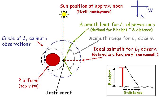
In reference to guidelines by Zibordi et al. 2009, a basic schematic is provided below to identity the most favorable deployment geometry. Accounting that SeaPRISM measurements (LT) are performed with a water viewing angle of 40 degrees and a relative azimuth of 90 degrees with respect to the sun, the instrument should be deployed in an unobstructed location allowing for the most favorable measurement conditions during a satellite overpass (i.e., generally around 12 p.m. local time). The sensor should view the water surface at a distance from the platform (S) that is at least the height of the deployment superstructure (P) to minimize superstructure perturbations (i.e., S ≥ P). The water viewing angle of 40 degrees might require deploying the instrument a few meters away from the main structure or a few meters higher to maintain optimal measurements. Depending on the geometry of the superstructure, suitable angles for above water radiometric measurements are restricted to within thresholds which should be identified and applied to remove measurements likely appreciably affected by superstructure perturbations.
The SeaPRISM instrument control box must have the following parameters set:
- A Sea = ± 90, indicating the azimuth offset with respect to sun (-90 degrees is generally used for the north hemisphere while +90 degrees is used for the southern one); it is mentioned that the most recent version of the instrument allows reversing the sign of Asea during the day.
- Z Sea = 40, indicating the viewing angle of 40 degrees applied for sea observations;
- N Mes Sea = 11, indicating the number of sea observations performed with a viewing angle of 40 degrees and ± 90 degrees azimuth offset with respect to the sun;
- N Mes Sky = 3, indicating the number of sky observations following each series of sea observations, performed with a viewing angle of 140 degrees and azimuth offset of ± 90 degrees with respect to the sun.
|
| |
| Version |
| |
| |
The AERONET Version 3 algorithm is used for the direct sun measurements. The normalized water-leaving radiance algorithm (LWN) is at the base level, Version 1.
In addition to the AERONET-OC LWN data corrected for bidirectional effects relying on the method proposed by Morel et al. (2002, identified as LWN_f/Q), Version 3 data include alternative LWN products are determined based on the correction scheme for bi-directional effects proposed by Lee et al. (2011, identified as LWN_IOP). While LWN_f/Q data are generally recommended for applications related to Chla-dominated waters (i.e., Case 1), the alternative products LWN_IOP appear more suitable for optically complex waters (i.e., Case 2).
André Morel, David Antoine, and Bernard Gentili, "Bidirectional reflectance of oceanic waters: accounting for Raman emission and varying particle scattering phase function," Appl. Opt. 41, 6289-6306 (2002)
Zhong Ping Lee, Keping Du, Kenneth J. Voss, Giuseppe Zibordi, Bertrand Lubac, Robert Arnone, and Alan Weidemann, "An inherent-optical-property-centered approach to correct the angular effects in water-leaving radiance," Appl. Opt. 50, 3155-3167 (2011) |
| |
| Quality Levels |
| |
| |
Normalized water-leaving radiances (Lwn) are provided in three levels: Level 1.0, 1.5, and 2.0. Level 1.0 data include Lwn determined from sequences of sea measurements taken with viewing geometries minimizing the platform perturbations. Level 1.5 data include screen Lwn corresponding to Level 1.0 products from measurement sequences not affected by a) cloud perturbations as determined from direct sun irradiance measurements, b) high variability in sea observations indicating elevated wave perturbations, or c) high Lwn values in the near infrared suggesting the presence of obstacles in the optical path between the instrument and the water surface. Level 2.0 data refer to fully quality-assured Lwn, corresponding to a) Level 1.5 products originated from SeaPRISMs exhibiting differences smaller than 5% between the calibration coefficients determined before and after typical one-year deployment periods, b) coincident aerosol optical depth of Level 2.0, and c) quality-assured statistical assessment according to the algorithm described by D'Alimonte and Zibordi 2006 (Statistical assessment of radiometric measurements from autonomous systems IEEE Geosci. Remote Sens., 44, 719-728, 10.1109/TGRS.2005.862505.). |
| |
|
