Principle Investigation Contacts:
Field Participants:
Non Field Participants (not comprehensive)
Experimental Plan:
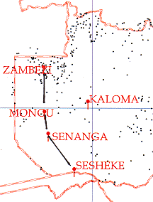
The experimental plan is detailed in Appendix 1 however the main focus was to measure the carbon flux from the massive amount of burning taking place to the east of the Western Province of Zambia, estimate direct radiative forcing due to smoke from biomass burning, and validate satellite aerosol retrievals. The measurement approach established a 400 km transect of ground based sun photometers (Figure 1) orthogonal to the prevailing easterlies then fly an in situ aerosol and trace gas sampling system in the transect to establish a 2-D measurement plain during a variety of meteorological and burning conditions.
Figure 1. The Zibbee transect followed the Zambezi River from Zambezi to Sesheke.
The ground-based measurement network will remain in operation for the duration of the burning season. Appropriate satellite, meteorological and ancillary ground based data were collected. Four cimel automatic sun-sky scanning spectral radiometers were maintained at Sesheke, Senanga, Mongu and Zambezi. All sites were calibrated with two additional reference instruments (Figure 2).
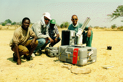
Figure 2. One of four automatic ground based sun photometers established
in the Zambezi transect.
Solar flux measurements were established at Mongu, Zambezi, and Senanga. Total
column ozone and AOT from hand-held microtops instruments were established at
Mongu, temporary, and mobile sites (Figure 3).
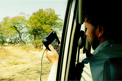
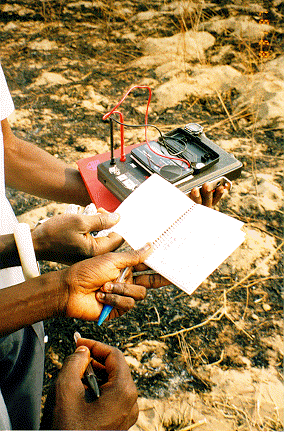
Figure 3. Microtops handheld sun photometers augmented data collection
between primary sites during overflights, from the aircraft and as a backup
at primary sites.
A micropulse lidar was deployed at Mongu for continuous monitoring of the aerosol profile. Low volume particulate mass samples were collected on Teflon filters with a six hour replacement schedule. An additional site for automatic cimel measurrements and micotops was established midway between Senanga and Mongu on flight days (Figure 4).
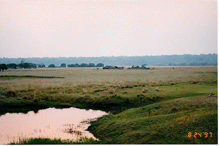
Figure 4. The Dambo measurement site (Letoya) between Mongu and Senanga.
Automatic weather stations were established the previous year at Senanga, Mongu
and Zambezi by the USFS. An 20 site network of 2-band hand-held sun photometers
was established at and between the four principle sites. Measurements will be
made half hourly for two months (Sept.-Oct.) and will help to provide spatial
continuity between the primary stations (Figure 5).
A micropulse lidar (MPL) was deployed at Mongu for continuous monitoring of
the aerosol profile (Figure 6).
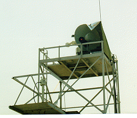
Figure 6. A micropulse lidar was installed on a tower at the Mongu Meteorological
office. Continuous measurements of aerosol profiles were collected during the
experiment.
An airborne instrument package which included in situ measurements of ozone,
aerosol filter samples, canister samples, WS, WD, relative humidity, CO, CO2,
backscatter and location information was loaded onto a cessna 206. Due to scheduling
conflicts with big game hunters, planes from several different companies provided
intermittent flight support during the experiment. This was further complicated
by delayed surface transport of the avgas to Mongu from Lusaka.
As of 7-9-97 four aircraft flights had been completed in the southern transect
between Sesheke, Senanga, and Mongu. Beginning 9-9-97, the full transect will
be flown. High and low flights were made across the southern transects and profiles
made over the primary sites.
Dr. Jay Herman developed a special two day aerosol index composite over Southern Africa which was available for the duration of the project thru ftp://jwocky.gsfc.nasa.gov/pub/tmp/s_africa/composite. Daily data were also archived.
Dr. Sundar Christopher will use AVHRR imagery to estimate radiative forcing
and Ms. Jackie Kendall will estimate fire numbers. Dr. Eric Vermote will estimate
radiative properties of aerosols, aerosol optical depths and cloud droplet size
distributions from AVHRR data. Data will be intered where applicable
into a GIS data base to facilitate spatial and temporal analysis.
Table 1. Lists the type, location and duration of data
collected during the experiment, Aug. 20 to Sept. 24.
| Location | Waypoint | Data Type | Duration | Comment |
|---|---|---|---|---|
| Mongu |
S 15° 15.266' E 023° 09.028' |
Cimel-AOT, size dist | June-Oct | Recalibrate Aug. 25 |
| Mongu | as above | AOT | Aug. 31 to Sept. 26, hourly | Microtops |
| Mongu | as above | AOT, 2-Band | Homemade handheld | |
| Mongu | as above | Ozone Microtops | Aug. 26-Sept. 26 | |
| Mongu | as above | PAR |
Sept.3-12 and Sept. 15-present (and continuing) |
DCP Automatic Satellite Tansmission 1 min. sampling |
| Mongu | as above | Spectral Hemispher | Optronics Data | |
| Mongu | as above | Eppley |
Aug. 22-Sept. 1 and Sept. 4 and 5 |
Eppley PSP 2-4 min. sampling |
| Mongu | as above | Microtops | ||
| Mongu | as above | Aerosol profile | Aug. 22- Sept. 17 | Lidar Data-MPL |
| Mongu | as above | Scanning Lidar | Aug. 29-30; Sept 2,4 | MPL |
| Mongu | as above | MET data | Year Around, hourly | Automatic and observer |
| Mongu | as above | Low Vol. Filter | Sept. 3 to Sept 13 | 6 hr replacement |
| Zambezi |
S 13° 32.000' E 023° 06.000' |
AOT, size dist | Aug. 25 to Sept. 26 | Cimel |
| Zambezi | as above | Met data | Year Around, hourly | Automatic and observer |
| Zambezi | as above | Eppley | Aug. 27-? | Logged w/ Auto Met Station |
| Zambezi | as above | AOT, 2-Band | 2-Band | Homemade handheld |
| Senanga |
S 16° 06.679' E 023° 17.873' |
AOT, size dist | Aug. 25 to Sept. 26 | Cimel |
| Senanga | as above | PAR | ||
| Senanga | as above | Eppley |
Aug. 24-26 Aug. 28-30 Sept. 5-14 |
Eppley PSP 3-5 min. sampling |
| Senanga | as above | AOT, 2-Band | 2-Band | Homemade handheld |
| Sesheke |
S 17° 28.618' E 024° 18.070' |
AOT, size dist | Aug. 25 to Sept. 26 | Cimel |
| Sesheke | as above | AOT, 2-Band | Homemade handheld | |
| Airborne | AOT, Microtops | thru windshield | ||
| Airborne Package: | backscatter | Neph | ||
| Ozone | ||||
| Temp | ||||
| Humidity | ||||
| Pressure | ||||
| WS | ||||
| WD | ||||
| Canisters | ||||
| Filters | ||||
| GPS | ||||
| Chitoke |
S 13° 50.44' E 023° 12.573' |
AOT, 2-Band | Homemade handheld | |
| Kalong |
S 16° 14.735' E 023° 14.255' |
AOT, 2-Band | Homemade handheld | |
| Lotoya |
S 15° 40.617' E 023° 18.002' |
AOT, 2-Band | Homemade handheld | |
| Luku8S |
S 14° 23.619' E 023° 14.907' |
AOT, 2-Band | Homemade handheld | |
| Lukulu |
S 14° 23.111' E 023° 14.617' |
AOT, 2-Band | Homemade handheld | |
| Mob |
S 14° 40.036' E 022° 41.356' |
AOT, 2-Band | Homemade handheld | |
| Mongu |
S 15° 15.266' E 023° 09.028' |
AOT, 2-Band | Homemade handheld | |
| Moombo |
S 15° 04.115' E 023° 10.045' |
AOT, 2-Band | Homemade handheld | |
| Nachgg |
S 14° 52.671' E 023° 04.456' |
AOT, 2-Band | Homemade handheld | |
| Nachgi |
S 14° 52.680' E 023° 18.226' |
AOT, 2-Band | Homemade handheld | |
| Namush |
S 15° 34.866' E 023° 18.226' |
AOT, 2-Band | Homemade handheld | |
| Senanc |
S 16° 06.679' E 023° 17.873' |
AOT, 2-Band | Homemade handheld | |
| Senann |
S 16° 04.678' E 023° 18.702' |
AOT, 2-Band | Homemade handheld | |
| Senans |
S 16° 08.223' E 023° 17.253' |
AOT, 2-Band | Homemade handheld | |
| Seshek |
S 17° 28.618' E 024° 18.070' |
AOT, 2-Band | Homemade handheld | |
| Silumb |
S 16° 55.431' E 023° 52.332' |
AOT, 2-Band | Homemade handheld | |
| Sioma |
S 16° 35.932' E 023° 30.062' |
AOT, 2-Band | Homemade handheld | |
| Sivand |
S 15° 34.957' E 023° 17.900 |
AOT, 2-Band | Homemade handheld | |
| Zambez |
S 13° 32.000' E 023° 06.000' |
AOT, 2-Band | Homemade handheld |
Meteorology and burning conditions--Typically August, Sept. and Oct are the
periods of most intensive burning in this region. August to Sept. 10 appeared
fairly typical but two unseasonable rain events removed the aerosol and stopped
extensive burning for approximately 1 week. The subsequent buring remained fairly
sparse resulting is low aerosol loading as of Sept. 24.
August 20 to 30: Entirely Cloud free, smoke variable from light to very heavy
aerosol loading Average AOT @ 500 nm 0.8.
Aug. 31- Sept. 1, Partly cloudy to overcast, morning winds up to 12 m/sec. Some
dust noted.
Sept. 1- 5. Clear heavy smoke.
Sept. 5 and 6: Partly cloudy with middle clouds AS & AC, smoke heavy.
Sept. 7 cldy
Sept. 8-9: Mostly clear, smoke heavy.
Sept. 10: Rain. Little smoke
Sept. 11-13: Overcast. No smoke
Sept. 14,15, 16 rain Cldy and rain
Sept. 17: Largely clear, little smoke
Sept. 18-19, 20, 21, 22, : Mostly Overcast, little smoke
Sept. 23, 24, 25: partly cldy, little smoke
The success of the experiment was largely dependent on the considerable efforts
of Mr. Mukufute Matongo Mukelabai (Figure 7), Provincial Meteorological Officer
of the Mongu Meteorological Office. Mr. Mukelabai organized our activities with
the Mongu Aviation Authority and gained authorization for the experiment with
the Pemanent Secretary of the Western Province, Mr. T. Muliokela. Our great
appreciation to Mr. Muliokela for the green light to study smoke over his juristiction.
Mr. Mukelabai provided excellent laboratory and storage facilities for the equipment
and office space for the visiting scientists. Additionally the Met. staff provided
valuable meteorological council and actively participated in data collection,
entry and analysis for the ground based and airborne campaigns.
Figure 7. Muke and Bob Swap, note Muke's hat.
Also our appreciation to Mr. Gabriel B.Chipeta, Director Zambian Meteorology,
Mr. Collins Mweene and the staff at Zambian Meteorological Headquarters in Lusaka
for providing internet service, surface wind fields, clearing our equipment
through customs and facilitating collaboration with various field offices.
My thanks to Dr. Sang Lee for allowing us to take the unusual step of renting
the MPL to us on very short notice. The resulting data set will push the ground
based aerosol measurements to a new level of understanding. Also thanks to the
Solar Light Company for loaning us the Microtops ozone meter which extended
our ground based validation capability.
A final note, Dr. Darold Ward (Figure 8) of the US Forest Service Fire Chemistry
Lab. has spent considerable time preparing for this experiment with numerous
visits and ground based experiments in Zambia over the past five years. His
bold efforts led to the design and successful execution of the most extensive
ground based sun photometer network attempted in aerosol research. This combined
with flying scientific instrument packages in regions of limited infrastructure
has afforded the rest of us a unique opportunity to study one of the most important
biomass burning regions on the planet.

Figure 8. Dr. Darold Ward - USFS Fire Chemistry Lab.
E-mail Distribution List:
kaufman@climate.gsfc.nasa.gov
mmuke@zamnet.zm
darold@mail.zamnet.zm
brent@spamer.gsfc.nasa.gov
darrel@ltpmail.gsfc.nasa.gov
PYROWARD@aol.com
rjs8g@amazon.evsc.virginia.edu
thompson@gator1.gsfc.nasa.gov,
justice@kratmos.gsfc.nasa.gov
Didier.Tanre@univ-lille1.fr
jaile@loaser.univ-lille1.fr
boucher@loaser.univ-lille1.fr
ross@ltpmail.gsfc.nasa.gov
torres@hoss.stx.com
hsu@hoss.stx.com
bhartia@carioca.gsfc.nasa.gov
herman@tparty.gsfc.nasa.gov
remer@climate-f.gsfc.nasa.gov
Catherine.Liousse@cfr.cnrs-gif.fr
ilya@aeronet.gsfc.nasa.gov, asmirnov@aeronet.gsfc.nasa.gov, teck@aeronet.gsfc.nasa.gov,
wnewcomb@aeroent.gsfc.nasa.gov, brent@aeronet.gsfc.nasa.gov, lblasingame@ltpmail.gsfc.nasa.gov,
nader@spamer.gsfc.nasa.gov
eric@kratmos.gsfc.nasa.gov
curran@umbc.edu
brianm@ltpmail.gsfc.nasa.gov
sundar@force.atmos.uah.edu
King@climate
jackie@hades.gsfc.nasa.gov
jspin@virl.gsfc.nasa.gov
kinne@spamer.gsfc.nasa.gov
sesi@erols.com