|
|
 |
AERONET Site Information Database
Alboran (Alboran, Spain)
Site Index
|
|
|
Image
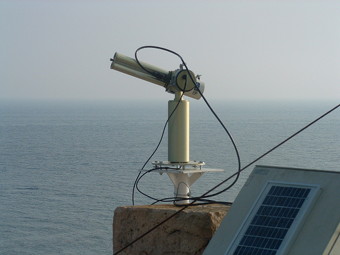
1 - View of the sunphotometer. |
| Image
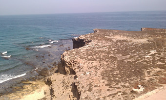
2 - View |
|
Image 1
|
Image 2
|
|
|
Site Coordinates and Elevation:
|
- Latitude: 35.93962° North
- Longitude: 3.35297° West
- Elevation: 15.0 Meters
|
|
Site
Description:
|
- The instrument is installed at the Alboran Island in the South-western Mediterranean Sea, 200 km East from the Gibraltar Strait, 55 km North from Morocco and 85 km South from Spain. The island has an area of 0.071 km2 and it is a nearly flat platform with a maximum height of 15 m asl. The site, maintained in cooperation with the Spanish Royal Army Observatory, is uninhabited (except for some minimal logistical military presence). The most important feature of this site is the lack of local anthropogenic activities.
|
|
Principal
Investigator(s)
Information:
|
- Lucas Alados Arboledas
- E-mail: alados@ugr.es�
Lucas Alados Arboledas
Andalusian Institute for Earth System Research (IISTA)
Avd. Mediterraneo s/n
18006, Granada, Spain
Email: : alados@ugr.es
Phone +34 249755-249749
|
|
Site
Manager(s) Information:
|
- Francisco Jose Olmo Reyes
- Email: fjolmo@ugr.es
-
Francisco Jose Olmo Reyes
Andalusian Institute for Earth System Research (IISTA)
Avd. Mediterraneo s/n
18006, Granada Spain
Email: fjolmo@ugr.es
Phone +34 958 241000-Ext 31169
Fax +34 958 137246
|
|
Responsible
Institution(s):
|
-
Andalusian Center for Environmental Research CEAMA (http://www.ceama.es/)
University of Granada (www.ugr.es)
|
|
Email Amy Scully
for content and picture updates.
Last Generated: 15 MAY 2024
|