|
|
 |
AERONET Site Information Database
Site Index
|
|

|
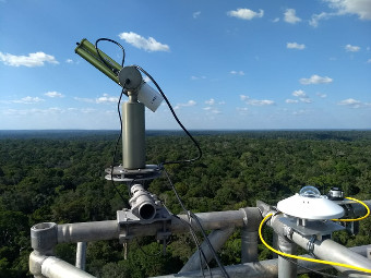
Image
1 - View of the sunphotometer. |
| Image
2 - n/a |
|
Image 1
|
Image 2
|
|
|
Site Coordinates and Elevation:
|
- Latitude: 2.14412° South
- Longitude: 58.99987° West
- Elevation: 210.0 Meters
|
|
Site
Description:
|
- The ATTO tower is located about 150 Km Northeast of Manaus, in a protected primary forest site. The site do not have any local air pollution sources, and the wind direction is mostly from the Northeast. The site receives pristine air masses that have passed only over forest area for more than 2000 Km. Occasionally we receive air masses from the Sahara desert and from biomass burning emissions from Africa.
|
|
Principal
Investigator(s)
Information:
|
- Paulo Artaxo
- E-mail: artaxo@if.usp.br
Prof. Paulo Artaxo
Instituto de Fisica
Universidade de Sao Paulo
Rua do Matao, 1371
05508-900, Sao Paulo, SP, Brazil
Phone:+[55] (11) 3091 7016
E-mail: artaxo@if.usp.br
|
|
Site
Manager(s) Information:
|
|
|
Responsible
Institution(s):
|
-
Laboratório de Física Atmosférica, Instituto de Física
Universidade de São Paulo
|
|
Email Amy Scully
for content and picture updates.
Last Generated: 10 MAY 2024
|