|
|
 |
AERONET Site Information Database
Site Index
|
|
|
Image
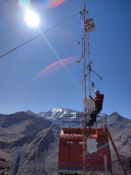
1 - view of the sunphotometer |
| Image
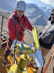
2 - view of the sunphotometer |
|
Image 1
|
Image 2
|
|
|
Site Coordinates and Elevation:
|
- Latitude: 33.31800° South
- Longitude: 70.23300° West
- Elevation: 3685.0 Meters
|
|
Site
Description:
|
- The instrument is located on a platform on top of the mountain refuge at the Cerro Tres Puntas, Valle Nevado, Lo Barnechea, Santiago. The instrument has a view to the highest peaks in the Santiago region and is located in one of the preferred routes of transport for air pollution that is emitted from the city of Santiago towards the Andes.
|
|
Principal
Investigator(s)
Information:
|
- Roberto Rondanelli
- E-mail: ronda@dgf.uchile.cl
Roberto Rondanelli
Av. Blanco Encalada 2002
Santiago, Chile
Phone+56229784307
Fax: + 56 2 26968686
Email: ronda@dgf.uchile.cl
AND
- Laura Gallardo
- E-mail: laura@dgf.uchile.cl
Laura Gallardo
Av. Blanco Encalada 2002
Santiago, Chile
Phone: +56229784307
Fax:+ 56 2 26968686
Email: laura@dgf.uchile.cl
|
|
Site
Manager(s) Information:
|
|
|
Responsible
Institution(s):
|
-
Center for Climate and Resilience Research
University of Chile
Santiago, Chile
www.cr2.cl
|
|
Email Amy Scully
for content and picture updates.
Last Generated: 10 MAY 2024
|