|
|
 |
AERONET Site Information Database
Site Index
|
|
|
Image
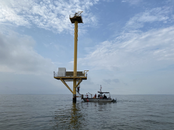
1 - Node installation August 26, 2021. Photo taken facing SSW. Instrument is being mounted on the southern corner of the upper platform (top left on the backside). |
| Image
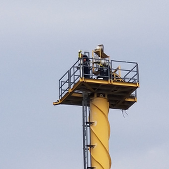
2 - Instrument installation on the southern corner of the upper platform 37m off the water. |
|
Image 1
|
Image 2
|
|
|
Site Coordinates and Elevation:
|
- Latitude: 39.12351° North
- Longitude: 76.34890° West
- Elevation: 30.0 Meters
|
|
Site
Description:
|
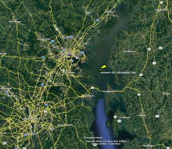
- The Chesapeake Tower node is mounted on a USCG-controlled navigational range-light tower (Tolchester Channel Rear Range Light) with a lower platform for solar panels and battery storage (see photos below) and an upper platform where the SEAPRISM system is mounted. The single-pile, yellow tower stands in the upper Chesapeake Bay ~28 km ESE of Baltimore harbor, ~15 km N of the Rte. 50 bridge, well outside of commercial shipping lanes surrounded by highly turbid, optically deep, 6-8 m depth waters. Distances to the shoreline are 7.1 km W, 13.6 km N, 9.1 km E, 13.1 km S.
|
|
Principal
Investigator(s)
Information:
|
- Dirk Aurin
- E-mail: dirk.a.aurin@nasa.gov
Dirk Auriin
NASA Goddard Space Flight Center (GSFC)
Code 616
Greenbelt, MD 20771 USA
Tel: 301-286-8156
Cell: 860-876-5055
|
|
Site
Manager(s) Information:
|
- John "Rusty" McKay
- Email: John.McKay@maryland.gov
-
John "Rusty" McKay
Section Head, Shellfish Monitoring Section
Water and Science Administration
Maryland Department of the Environment
416 Chinquapin Round Road
Annapolis, Maryland 21401
Email: John.McKay@maryland.gov
AND
- Michael Ondrusek
- Email: michael.ondrusek@noaa.gov
-
Michael Ondrusek
Oceanographer
NOAA/NESDIS/STAR
Email: michael.ondrusek@noaa.gov
cell: 202-230-2405
|
|
Responsible
Institution(s):
|
-
National Aeronautics and Space Administration (NASA)
https://www.nasa.gov
AERONET Project
https://aeronet.gsfc.nasa.gov
|
|
Email Amy Scully
for content and picture updates.
Additional Photographs and Images
| CAPTION | IMAGE |
|---|
|
Image 3 - Site location in the upper Chesapeake Bay.
| 
|
Last Generated: 9 MAY 2024
|