|
|
 |
AERONET Site Information Database
Dunedin (Dunedin, New Zealand)
Site Index
|
|
|
Image
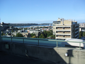
1 - This is a south easterly view. The Otago Harbour is the stretch of water seen in the middle of the picture.�The university chemistry building can be seen near the right of the picture.� |
| Image
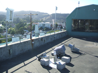
2 - View of the sunphotometer. |
|
Image 1
|
Image 2
|
|
|
Site Coordinates and Elevation:
|
- Latitude: 45.86394° South
- Longitude: 170.51364° East
- Elevation: 43.0 Meters
|
|
Site
Description:
|
- The site is on top of a six storey building, located on the University of Otago campus. It is an urban coastal location in a city of approximately 120,000 people.�
|
|
Principal
Investigator(s)
Information:
|
- Pawan Gupta
- E-mail: pawan.gupta@nasa.gov
-
Pawan Gupta
NASA Goddard Space Flight Center
Code 618. Bldg.33. Rm.G412
Greenbelt, MD. 20771
Tel: 301-614-6658
Email: pawan.gupta@nasa.gov
- Elena Lind
- E-mail: elena.lind@nasa.gov
-
Elena Lind
NASA Goddard Space Flight Center
Code 618. Bldg.33. Rm.G414
Greenbelt, MD 20771
Tel: 301-614-6629
Email: elena.lind@nasa.gov
|
|
Site
Manager(s) Information:
|
- Nigel McDonald
- Email: nam@geography.otago.ac.nz
-
Nigel McDonald
University of Otago
Department of Geography
Level 4, Richardson Building
85 Albany St.
Dunedin 9056, New Zealand
Phone: 64-3-479 8768
Email: nam@geography.otago.ac.nz
|
|
Responsible
Institution(s):
|
|
|
Email Amy Scully
for content and picture updates.
Last Generated: 9 MAY 2024
|