|
|
 |
AERONET Site Information Database
Site Index
|
|

|
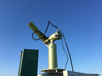
Image
1 - view of the sunphotometer |
| Image
2 - n/a |
|
Image 1
|
Image 2
|
|
|
Site Coordinates and Elevation:
|
- Latitude: 51.29000° North
- Longitude: 0.44000° East
- Elevation: 33.0 Meters
|
|
Site
Description:
|
- The sun photometer is located on top of a brick plinth and is collocated to a lidar instrument. The site comprises a large 35m x 36m enclosure with a range Met Office sensors (Relative Humidity, Temperature, Radiation, Rain, Wind Direction, Wind Speed etc.). The enclosure also houses a number of instruments belonging to East Malling Research, an agricultural research institute. The site is located in Kent, England, ~20 miles from the coast to the north-east and 30 miles from London to the north-west. It is the easternmost instrument within the Met Office volcanic ash network.
|
|
Principal
Investigator(s)
Information:
|
- Joelle Buxmann
- E-mail: joelle.c.buxmann@metoffice.gov.uk
Dr Joelle Buxmann
Senior Scientist
Met Office Observation Research and Development
Met Office, Fitzroy Rd
EX1 3PB, Exeter UK
Tel: +44 (0)1392 885620
Email: joelle.c.buxmann@metoffice.gov.uk
Alt Email: sunphotometer@metoffice.gov.uk
|
|
Site
Manager(s) Information:
|
- Tim Allot
- Email:
-
Tim Allot
Upper Air Remote Sensing Team Leader
Met Office Operational Observations
Met Office, Fitzroy Rd
EX1 3PB, Exeter UK
|
|
Responsible
Institution(s):
|
-
MO (Met Office, United Kingdom, Website: http://www.metoffice.gov.uk)
The instrument is funded by the Department for Transport (DfT) and will be integrated in a combined Lidar-sun photometer network for volcanic ash detection. Data quality is checked in collaboration with PHOTONS, University of Lille, France.
|
|
Email Amy Scully
for content and picture updates.
Last Generated: 10 MAY 2024
|