|
|
 |
AERONET Site Information Database
Site Index
|
|
|
Image
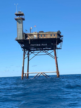
1 - View of the Frying Pan Tower. |
| Image
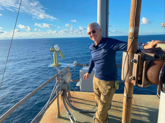
2 - Richard Neal with the Cimel Sunphotometer. |
|
Image 1
|
Image 2
|
|
|
Site Coordinates and Elevation:
|
- Latitude: 33.48530° North
- Longitude: 77.59010° West
- Elevation: 41.0 Meters
|
|
Site
Description:
|
- Frying Pan Tower or FPTower located offshore 36 mi east of Cape Fear, NC on eastern edge of Frying Pan shoals, 50 water depth. Nearest town Southport, NC. FPT formerly Coastal Guards lighthouse now privately owned. Aeronet SeaPrizm instrument installed on south east corner of top platform (16x16), fixed to rails safeguard, the platforms helipad is 85 feet above water with the light tower at 135 feet. The instrument has unobstructed 360° view above 10° of horizon. The instrument has clear view of sea surface from east to south, west-south-west sea surface view obstructed by platform.
|
|
Principal
Investigator(s)
Information:
|
- Pawan Gupta
- E-mail: pawan.gupta@nasa.gov
-
Pawan Gupta
NASA Goddard Space Flight Center
Code 618. Bldg.33. Rm.G412
Greenbelt, MD. 20771
Tel: 301-614-6658
Email: pawan.gupta@nasa.gov
- Elena Lind
- E-mail: elena.lind@nasa.gov
-
Elena Lind
NASA Goddard Space Flight Center
Code 618. Bldg.33. Rm.G414
Greenbelt, MD 20771
Tel: 301-614-6629
Email: elena.lind@nasa.gov
|
|
Site
Manager(s) Information:
|
- Richard Neal
- Email: richard@fptower.org
-
Richard Neal
FPTower Inc
4005 Watercraft Ferry Ave Unit 302
Wilmington NC 28412
Tel: +1 704-907-0399
Email: richard@fptower.org
|
|
Responsible
Institution(s):
|
-
NASA Goddard Space Flight Center
AERONET Project
https://aeronet.gsfc.nasa.gov
FPTower Inc
4005 Watercraft Ferry Ave Unit 302
Wilmington NC 28412
|
|
Email Amy Scully
for content and picture updates.
Last Generated: 10 MAY 2024
|