|
|
 |
AERONET Site Information Database
HBOI (Fort Pierce, FL)
Site Index
|
|

|
Image
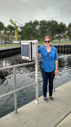
1 - View of the sunphotometer. |
| Image
2 - n/a |
|
Image 1
|
Image 2
|
|
|
Site Coordinates and Elevation:
|
- Latitude: 27.53430° North
- Longitude: 80.35690° West
- Elevation: 5.0 Meters
|
|
Site
Description:
|
- This is a temporary site for purposes of equipment testing. The instrument is installed on a railing along the ship channel on the Harbor Branch campus facing southeast. The campus is located on the landward side of the Indian River Lagoon, approximately 4 km from the Atlantic ocean.
|
|
Principal
Investigator(s)
Information:
|
- Nima Pahlevan
- E-mail: nima.pahlevan@nasa.gov
Nima Pahlevan
Science Systems and Applications, Inc.
NASA Goddard Space Flight Center / Code 619
8800 Greenbelt Road, Greenbelt, MD 20771
Bldg. 32, Rm S036N
Tel: 301-614-6684
Email: nima.pahlevan@nasa.gov
|
|
Site
Manager(s) Information:
|
- Malcolm McFarland
- Email: mmcfarland@fau.edu
-
Malcolm McFarland
Harbor Branch Oceanographic Institute Florida Atlantic University
5600 US Highway 1 North
Fort Pierce, FL 34946
Office: 772-242-2234
Mobile: 401-225-9204
Email: mmcfarland@fau.edu
|
|
Responsible
Institution(s):
|
|
|
Email Amy Scully
for content and picture updates.
Last Generated: 10 MAY 2024
|