|
|
 |
AERONET Site Information Database
Site Index
|
|

|
Image
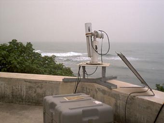
1 - A view of the instrument site. |
| Image
2 - The site manager with the sunphotometer. |
|
Image 1
|
Image 2
|
|
|
Site Coordinates and Elevation:
|
- Latitude: 36.56500° North
- Longitude: 34.25500° East
- Elevation: 3.0 Meters
|
|
Site
Description:
|
- This site is located on the roof of the Institute of Marine Sciences-Middle East Technical University, which is a rural site on the southeastern coast of Turkey (eastern Mediterranean).
|
|
Principal
Investigator(s)
Information:
|
- Pawan Gupta
- E-mail: pawan.gupta@nasa.gov
-
Pawan Gupta
NASA Goddard Space Flight Center
Code 618. Bldg.33. Rm.G412
Greenbelt, MD. 20771
Tel: 301-614-6658
Email: pawan.gupta@nasa.gov
- Elena Lind
- E-mail: elena.lind@nasa.gov
-
Elena Lind
NASA Goddard Space Flight Center
Code 618. Bldg.33. Rm.G414
Greenbelt, MD 20771
Tel: 301-614-6629
Email: elena.lind@nasa.gov
|
|
Co-Investigator(s)
Information
|
- Mustafa Koçak
- E-mail: mkocak@ims.metu.edu.tr
Mustafa Koçak
Middle East Technical University,
Institute of Marine Sciences,
P.O.Box 28, 33731,
Erdemli-Mersin, TURKEY
Phone: +90-324 521 2406
Fax: +90-324 521 2327
Email: mkocak@ims.metu.edu.tr
|
|
Site
Manager(s) Information:
|
- Mustafa Koçak
- Email: mkocak@ims.metu.edu.tr
-
Mustafa Koçak
Middle East Technical University,
Institute of Marine Sciences,
P.O.Box 28, 33731,
Erdemli-Mersin, TURKEY
Phone: +90-324 521 2406
Fax: +90-324 521 2327
Email: mkocak@ims.metu.edu.tr
|
|
Responsible
Institution(s):
|
|
|
Email Amy Scully
for content and picture updates.
Additional Photographs and Images
| CAPTION | IMAGE |
|---|
|
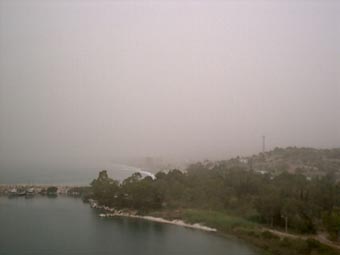
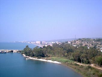
Image 3 - This site is strongly affected by mineral dust transport from Africa. In these photos you can see a view of the nearby coast under a severe dust storm on May 30, 2003 and the same view after the storm on June 4, 2003.
| 
|
|
Image 4 - June 4, 2003
| 
|
|
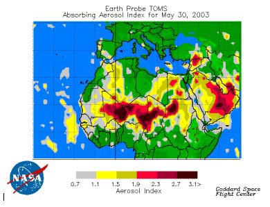
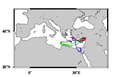
Image 5 - These maps show NASA's TOMS (Total Ozone Mapping Spectrometer) absorbing aerosol index on May 30, 2003. They show Saharan dust over Africa together with air mass back trajectories arriving at this site. The maps indicate and validate the hazy situation in the May 30th photo that resulted from dust transport.
| 
|
|
Image 6 - A map showing the dust trajectories over the Mediterranean Sea on May 30, 2003.
| 
|
Last Generated: 10 MAY 2024
|