|
|
 |
AERONET Site Information Database
Itajuba (Itajuba, Brazil)
Site Index
|
|
|
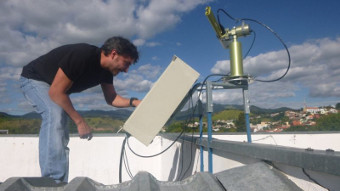
Image
1 - View of the sunphotometer |
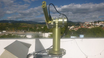
| Image
2 - View of the sunphotometer |
|
Image 1
|
Image 2
|
|
|
Site Coordinates and Elevation:
|
- Latitude: 22.41325° South
- Longitude: 45.45239° West
- Elevation: 856.0 Meters
|
|
Site
Description:
|
- The instrument is installed at the roof of a 3-floor building in the Federal University of Itajuba campus (Unifei). Unifei is located in the northern part of Itajuba City, in the border between urban and rural areas. Itajubá is surrounded by the Serra da Mantiqueira and shows a significant number of clear-sky days (the astronomical observatory is located some 40 km from the city). The winter months are dry and forest fires are observed between the end of winter and during the spring.
|
|
Principal
Investigator(s)
Information:
|
- Marcelo de Paula Correa
- E-mail: mpcorrea@unifei.edu.br
Marcelo de Paula Correa
IRN/Unifei
Av. BPS, 1303
CEP 37500-903
Itajuba/MG - Brazil
Phone: +55 35 36291449
E-mail: mpcorrea@unifei.edu.br
Alternative e-mail: mpcorrea@gmail.com
|
|
Site
Manager(s) Information:
|
- Marcelo de Paula Correa
- Email: mpcorrea@unifei.edu.br
-
Marcelo de Paula Correa
IRN/Unifei
Av. BPS, 1303
CEP 37500-903
Itajuba/MG - Brazil
Phone: +55 35 36291449
E-mail: mpcorrea@unifei.edu.br
Alternative e-mail: mpcorrea@gmail.com
|
|
Responsible
Institution(s):
|
-
Responsible Institution:
Universidade Federal de Itajuba (Federal University of Itajuba) - www.unifei.edu.br
Funding Organization:
Conselho Nacional de Desenvolvimento Científico e Tecnológico (The National Council for Scientific and Technological Development) - www.cnpq.br
|
|
Email Amy Scully
for content and picture updates.
Additional Photographs and Images
| CAPTION | IMAGE |
|---|
|
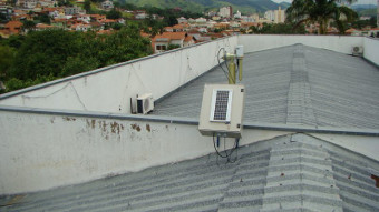
Image 3 - View of the sunphotometer
| 
|
Last Generated: 10 MAY 2024
|