|
|
 |
AERONET Site Information Database
Kupang (Kupang, Indonesia)
Site Index
|
|
|
Image
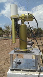
1 - View of the sunphotometer. |
| Image
2 - View of the sunphotometer. |
|
Image 1
|
Image 2
|
|
|
Site Coordinates and Elevation:
|
- Latitude: 10.13918° South
- Longitude: 123.66710° East
- Elevation: 30.0 Meters
|
|
Site
Description:
|
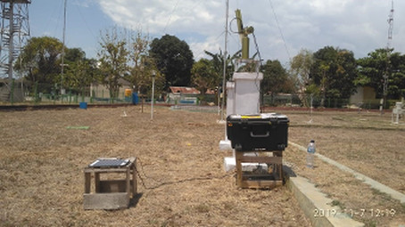
- The site is located in Kupang Climatological Station, 10,7 KM East of Kupang. The instrument is installed on a concrete base in an open field about 85 M of weather station building.
|
|
Principal
Investigator(s)
Information:
|
- Apolinaris S. Geru
- E-mail: apolinarissgeru@yahoo.com
Apolinaris S. Geru, SP. M.Si
Chief of Kupang Climatological Station
Jln. Timor Raya KM. 10,
7 Lasiana Kupang - NTT 85361
Email : apolinarissgeru@yahoo.com
Alt Email: staklim.kupang@bmkg.go.id
Tel: (0380) 881681
Fax: (0380) 881680
|
|
Site
Manager(s) Information:
|
- Hilman Firmansyah Pic
- Email: hilman.firmansyah@bmkg.go.id
-
Hilman Firmansyah Pic
Stasiun Klimatologi Kelas II NTT
Jl. Timor Raya KM. 10
7 Lasiana, Kupang
Nusa Tenggara Timur 85228 Indonesia
|
|
Responsible
Institution(s):
|
-
NASA Goddard Space Flight Center
AERONET Project
https://aeronet.gsfc.nasa.gov
|
|
Email Amy Scully
for content and picture updates.
Additional Photographs and Images
| CAPTION | IMAGE |
|---|
|
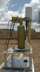
Image 3 - View of the sunphotometer.
| 
|
Last Generated: 9 MAY 2024
|