|
|
 |
AERONET Site Information Database
Laegeren (Laegeren, Switzerland)
Site Index
|
|
|
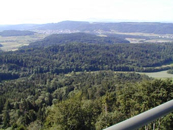
Image
1 - A view from the instrument site looking to the south. |
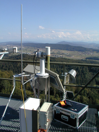
| Image
2 - A close-up view of the sunphotometer and the surroundings in�south-east direction. |
|
Image 1
|
Image 2
|
|
|
Site Coordinates and Elevation:
|
- Latitude: 47.47835° North
- Longitude: 8.36435° East
- Elevation: 763.0 Meters
|
|
Site
Description:
|
- The site is located on the southern slope of the Laegeren, which forms the eastern most part of the Jura mountains (NW of Zurich, Swiss Plateau). The site is located in a highly diverse forest, dominated by beech and fir. The instrument is placed on the highest platform of a measurement tower around 50 meter above ground. The site is in close vicinity to the cities of Wettingen and Baden (40000 citizens together) with a distance of 2 kilometers to the closest houses of the adjacent urban area. A motor highway is close-by with the nearest distance of 3.5 kilometers.
|
|
Principal
Investigator(s)
Information:
|
- Alexander Damm-Reiser
- E-mail: alexander.damm@geo.uzh.ch
Remote Sensing of Water Systems
Department of Geography
University of Zurich
Winterthurerstrasse 190
8057 Zürich
Switzerland
+41 (0) 44 635 5251
|
|
Site
Manager(s) Information:
|
- Michael Niederberger
- Email: michael.niederberger@uzh.ch
-
Remote Sensing of Water Systems
Department of Geography
University of Zurich
Winterthurerstrasse 190
8057 Zürich
Switzerland
+41 (0) 44 63 55103
|
|
Responsible
Institution(s):
|
-
Remote Sensing of Water Systems
Department of Geography, University of Zurich & Eawag, Swiss Federal Institute of Aquatic Science & Technology, Surface Waters Research and Management
https://geo.uzh.ch/rsws
Swiss National Science Foundation, grant number 197243
|
|
Email Amy Scully
for content and picture updates.
Last Generated: 10 MAY 2024
|