|
|
 |
AERONET Site Information Database
Learmonth (Learmonth, Australia)
Site Index
|
|

|
Image
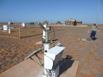
1 - The AeroSpan/AERONET cimel sun photometer set up at Learmonth, Western Australia. The buildings in the background other instruments are associated with the Australian Bureau of Meteorology. |
| Image
2 - n/a |
|
Image 1
|
Image 2
|
|
|
Site Coordinates and Elevation:
|
- Latitude: 22.24070° South
- Longitude: 114.09670° East
- Elevation: 9.0 Meters
|
|
Site
Description:
|
- (f) The Learmonth Solar Observatory (LSO) is located approx.. 3 km North of the Met Bureau station. The LSO is jointly operated by the U.S. Army and the Australian Bureau of Meteorology. (e) The Australian Bureau of Meteorology operates a station about 500m from the Learmonth airport terminal. The Learmonth AeroSpan/AERONET station is located near the Bureau of Meteorology instruments. Classified as RAAF bare base: Land owned by Department of Defence; can become active RAAF base if necessary; was used as such during WWII owing to its extreme westerly location. The region shows high frequency of dust storms, the source of which is possibly due to advection of dust from the Australian interior via the North-Western dust pathway. It is adjacent to the Ningaloo reef (coral) in the nearby Indian Ocean. The nearest town is Exmouth, 36km north of Learmonth
|
|
Principal
Investigator(s)
Information:
|
- Ian Lau
- E-mail: ian.lau@csiro.au
Ian Lau
CSIRO Mineral Resources
26 Dick Perry Avenue
Kensington, Western Australia
Australia. (Post code) 6151
Phone is +61 86436 8646
Email: ian.lau@csiro.au
|
|
Co-Investigator(s)
Information
|
- David Barker
- E-mail: david.barker@csiro.au
David Barker
CSIRO Environment
107-121 Station Street
Aspendale, Victoria,
Australia (postcode) 3195
Ph: +61-3-92394450
Email: david.barker@csiro.au
|
|
Site
Manager(s) Information:
|
- Andréa Bride
- Email: andrea.bride@bom.gov.au
-
Andréa Bride
Manager Learmonth Solar Observatory
Space Weather Network
Observing Systems & Operations, Data & Digital Group
Minilya-Exmouth Rd
Learmonth, WA, 6707
PO Box 199, Exmouth, WA, 6707
Email: andrea.bride@bom.gov.au
T: 08 9949 1472
M:0439 183 329
www.bom.gov.au
|
|
Responsible
Institution(s):
|
-
Commonwealth Scientific and Industrial Research Organization (CSIRO), Australia
|
|
Email Amy Scully
for content and picture updates.
Last Generated: 10 MAY 2024
|