|
|
 |
AERONET Site Information Database
Site Index
|
|

|
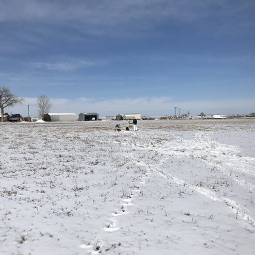
Image
1 - View of the sunphotometer. |
| Image
2 - n/a |
|
Image 1
|
Image 2
|
|
|
Site Coordinates and Elevation:
|
- Latitude: 40.03556° North
- Longitude: 104.88500° West
- Elevation: 1522.0 Meters
|
|
Site
Description:
|
- MAXAR (DigitalGlobe) calibration range near Ft. Lupton, CO. This area is surrounded by farmland. The Cimel is currently mounted to a 4 x 4 foot board that is placed in a large field (temporary on-site location until a platform can be built for it nearby).
|
|
Principal
Investigator(s)
Information:
|
- Michele Kuester
- E-mail: Michele.Kuester@maxar.com
Michele Kuester
Maxar Technologies
1601 Dry Creek Drive, Suite 260
Longmont, CO 80503
Tel: 303-684-1391
Email: Michele.Kuester@maxar.com
AND
- Tina Ochoa
- E-mail: tina.ochoa@maxar.com
Tina Ochoa
Maxar Technologies
1601 Dry Creek Drive, Suite 260
Longmont, CO 80503
Tel: +1.303.870.8805 mobile
Email: tina.ochoa@maxar.com
|
|
Site
Manager(s) Information:
|
- Michele Kuester
- Email: Michele.Kuester@maxar.com
-
Michele Kuester
Maxar Technologies
1601 Dry Creek Drive, Suite 260
Longmont, CO 80503
Tel: 303-684-1391
Email: Michele.Kuester@maxar.com
AND
- Tina Ochoa
- Email: tina.ochoa@maxar.com
-
Tina Ochoa
Maxar Technologies
1601 Dry Creek Drive, Suite 260
Longmont, CO 80503
Tel: +1.303.870.8805 mobile
Email: tina.ochoa@maxar.com
|
|
Responsible
Institution(s):
|
-
MAXAR DigitalGlobe
www.maxar.com
|
|
Email Amy Scully
for content and picture updates.
Last Generated: 10 MAY 2024
|