|
|
 |
AERONET Site Information Database
Site Index
|
|

|
Image
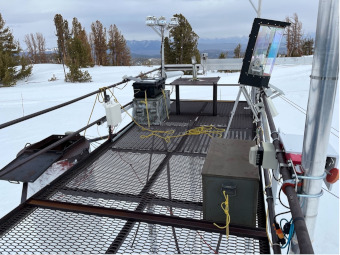
1 - Cimel #332 is visible in center of the image on the dark table in the parked position. |
| Image
2 - n/a |
|
Image 1
|
Image 2
|
|
|
Site Coordinates and Elevation:
|
- Latitude: 37.64300° North
- Longitude: 119.02900° West
- Elevation: 2940.0 Meters
|
|
Site
Description:
|
- Installed at the CRREL/UCSB energy site (CUES), on a table on top of a platform, approximately 6.5 m off bare ground. ��Bair, E. H., J. Dozier, R. E. Davis, M. T. Colee, and K. J. Claffey (2015), A study site for measuring snowpack energy balance in the Sierra Nevada, Frontiers in Earth Science, 3, 58, doi: 10.3389/feart.2015.00058.
|
|
Principal
Investigator(s)
Information:
|
- Thomas H. Painter
- E-mail: tpainter@jifresse.ucla.edu
Thomas H. Painter
Scientist
Jet Propulsion Laboratory
MS 300-233 California Institute of Technology
4800 Oak Grove Drive
Pasadena, CA 91109
Mobile +1 626.319.3111
Office +1 818.393.8226
Fax +1 818.354.9476
Email: tpainter@jifresse.ucla.edu
|
|
Site
Manager(s) Information:
|
- Ned Bair
- Email: nbair@eri.ucsb.edu
-
Ned Bair
SNARL
1016 Mount Morrison Road
Mammoth Lakes, CA 93546
Email: nbair@eri.ucsb.edu
|
|
Responsible
Institution(s):
|
-
NASA Goddard Space Flight Center
AERONET Project
https://aeronet.gsfc.nasa.gov
|
|
Email Amy Scully
for content and picture updates.
Last Generated: 10 MAY 2024
|