|
|
 |
AERONET Site Information Database
Site Index
|
|

|
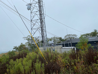
Image
1 - view of the sunphotometer. |
| Image
2 - n/a |
|
Image 1
|
Image 2
|
|
|
Site Coordinates and Elevation:
|
- Latitude: 41.82140° North
- Longitude: 73.29733° West
- Elevation: 510.0 Meters
|
|
Site
Description:
|
- The Mohawk Mountain site is an EPA approved NCORE rural regional-scale site operated by the CT Department of Energy and Environmental Protection. Beyond the existing 15m towers adjacent to the monitoring shelter, there is a open metal tower directly to the south (not shown in the site photo. The site is located at the summit of Mohawk Mountain and is approximately 17 km to the east of the New York border and 25m to the south of the Massachusetts border. The EPA operates a Pandora which is within the Pandonia Global Network for trace gas measurements of NO2, HCHO and O3. Should this site be selected a ceilometer can potentially be added by CTDEEP or EPA-ORD.
|
|
Principal
Investigator(s)
Information:
|
- Peter Babich
- E-mail: Pete.Babich@ct.gov
Peter Babich
9 Windsor Avenue
Windsor, CT 06095
Landline: 860-424-3422
Email: Pete.Babich@ct.gov
|
|
Site
Manager(s) Information:
|
- Peter Babich
- Email: Pete.Babich@ct.gov
-
Peter Babich
9 Windsor Avenue
Windsor, CT 06095
Landline: 860-424-3422
Email: Pete.Babich@ct.gov
|
|
Responsible
Institution(s):
|
|
|
Email Amy Scully
for content and picture updates.
Last Generated: 10 MAY 2024
|