|
|
 |
Back to Map
Mongu (Mongu, Zambia)
|
Coordinates:
15.25361° S,
23.15083° E
Elevation: 1047.0 m
|
Site Description
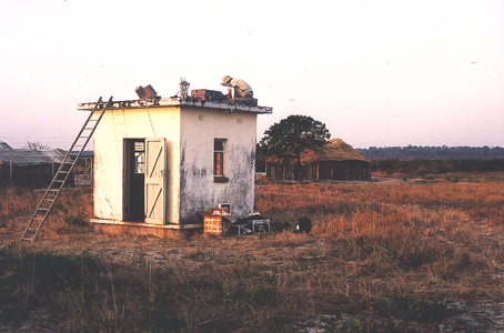
This site is located on the rooftop of the local airport approximately 2.5m above ground. The airport is surrounded by residential areas, but no industry. Mongu is mainly sandy with a seasonal flood plain that is burned to the west annually from July through November.
|
| Contact Information |
|
Principal Investigator(s):
|
- Pawan Gupta
- E-mail: pawan.gupta@nasa.gov
-
Pawan Gupta
NASA Goddard Space Flight Center
Code 618. Bldg.33. Rm.G412
Greenbelt, MD. 20771
Tel: 301-614-6658
Email: pawan.gupta@nasa.gov
- Elena Lind
- E-mail: elena.lind@nasa.gov
-
Elena Lind
NASA Goddard Space Flight Center
Code 618. Bldg.33. Rm.G414
Greenbelt, MD 20771
Tel: 301-614-6629
Email: elena.lind@nasa.gov
|
|
Site Manager(s):
|
- Mukufute Mukulabai
- Email: mukelabaim@googlemail.com
-
Mukufute M. Mukelabai
Zambia Meteorological Department
Mongu Airport
PO BOX 910144, Mongu, Zambia.
ph: +260 7 221643; Cell: + 260 097 237 606
Met. Office - 260 7221600
E-mail: mukelabaim@googlemail.com
|
|
Responsible
Institution(s):
|
|
|
Email Amy Scully
for content and picture updates.
Last Generated: 18 MAY 2024
|