|
|
 |
AERONET Site Information Database
Site Index
|
|
|
Image
1 - Instrument set up within the High Park burn area. |
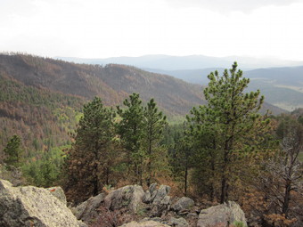
| Image
2 - View of the burn area around the instrument location. |
|
Image 1
|
Image 2
|
|
|
Site Coordinates and Elevation:
|
- Latitude: 40.62417° North
- Longitude: 105.33558° West
- Elevation: 2483.0 Meters
|
|
Site
Description:
|
- Instrument set up on tripod in the High Park Fire Burn area, approximately 22 km NW of Fort Collins, CO.
|
|
Principal
Investigator(s)
Information:
|
- Tom Kampe
- E-mail: tkampe@neoninc.org
Tom Kampe, PhD
National Ecological Observatory Network, Inc.
1685 38th St., Suite 100
Boulder, CO 80301
Ph: (720) 836-2414
Email: tkampe@neoninc.org
|
|
Site
Manager(s) Information:
|
- Nathan Leisso
- Email: nleisso@neoninc.org
-
Nathan Leisso, PhD
National Ecological Observatory Network (NEON)
1685 38th Street Suite 100
Boulder, CO 80301
office: 720.746.4855
mobile: 520.490.8043
Email: nleisso@neoninc.org
|
|
Responsible
Institution(s):
|
-
National Ecological Observatory Network, Inc. (NEON)
www.neoninc.org
|
|
Email Amy Scully
for content and picture updates.
Last Generated: 9 MAY 2024
|


