|
|
 |
AERONET Site Information Database
Site Index
|
|

|
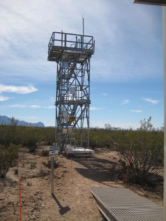
Image
1 - view of the tower. |
| Image
2 - n/a |
|
Image 1
|
Image 2
|
|
|
Site Coordinates and Elevation:
|
- Latitude: 31.91068° North
- Longitude: 110.83549° West
- Elevation: 983.0 Meters
|
|
Site
Description:
|
- Photometer is mounted on the SW Corner of the NEON observation tower. Tower is metal frame, 26' tall. NOTE: the tower height is NOT included in the elevation stated above in part d. (SRER - Santa Rita Experimental Range - University of Arizona) Santa Rita Experimental Range encompasses 21,000 hectares of upland Sonoran Desert, approximately 32 km south of Tucson, Arizona. Santa Rita Experimental Range was founded in 1903. It is the longest continuously active rangeland research facility and among the five oldest biological field stations in the United States.�
|
|
Principal
Investigator(s)
Information:
|
- Janae Csavina
- E-mail: jcsavina@battelleecology.org �
Janae Csavina
1685 38th Street, Suite 100
Boulder CO 80301
Email: jcsavina@battelleecology.org
Tel: (720) 330-1549, (720) 330-1526
|
|
Site
Manager(s) Information:
|
|
|
Responsible
Institution(s):
|
-
National Ecological Observatory Network (NEON) http://www.neonscience.org/
NEON is a project sponsored by the National Science Foundation and operated under cooperative agreement by Battelle
|
|
Email Amy Scully
for content and picture updates.
Last Generated: 10 MAY 2024
|