|
|
 |
Back to Map
|
Coordinates:
1.38433° N,
103.75453° E
Elevation: 25.0 m
|
Site Description
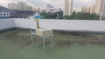
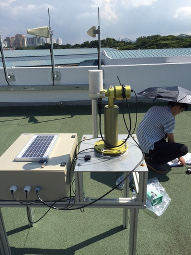
Instrument is set up in roof top with unobstructed view except for some small mobile telephony antennas. The instrument is located at the north west of Singapore, between two forested areas. Site still located inside urban environment.�
|
| Contact Information |
|
Principal Investigator(s):
|
- Santo V. Salinas Cortijo
- E-mail: crsscsv@nus.edu.sg
Santo V. Salinas Cortijo
Research Scientist
Centre for Remote Imaging, Sensing and Processing (CRISP)
Phone#65 6516 5173
|
|
Site Manager(s):
|
- Tan Li
- Email: crstanl@nus.edu.sg
-
Tan Li
Centre for Remote Imaging
Sensing and Processing
National University of Singapore
S17 Level 2, Lower Kent Ridge Road
Singapore 119260
Tel: 6516 4145
Email: crstanl@nus.edu.sg
|
|
Responsible
Institution(s):
|
-
National Research Foundation, Office for Space Technology and Industry Space Research Programme
(project number S15- 1319-NRF OSTIn-SRP).
|
|
Email Amy Scully
for content and picture updates.
Last Generated: 18 MAY 2024
|