|
|
 |
AERONET Site Information Database
Site Index
|
|
|
Image
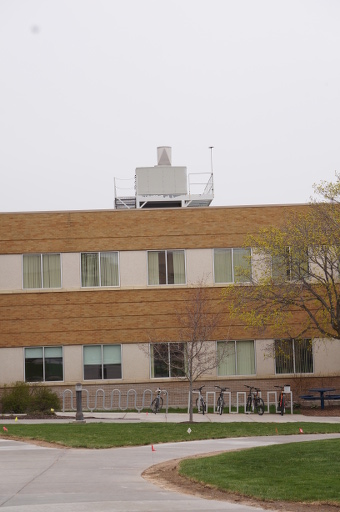
1 - A view of the south west corner of the George Romney building on the Brigham Young University Idaho Campus in Rexburg Idaho. The platform seen on the building roof will support the AERONET sensor. The sensor will be mounted to the North side of the platform (left side). |
| Image
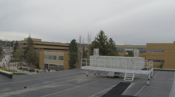
2 - A view of the platform on the George Romney building on the Brigham Young University Campus in Rexburg, Idaho, looking South. The AERONET sensor will be mounted on the North side of the platform. |
|
Image 1
|
Image 2
|
|
|
Site Coordinates and Elevation:
|
- Latitude: 43.82011° North
- Longitude: 111.78301° West
- Elevation: 1501.0 Meters
|
|
Site
Description:
|
- We propose placing the AERONET solar photometer on the roof of the Romney building on the BYU-Idaho campus in Rexburg, Idaho, USA. Maps and photographs showing the location are attached (Figures 1-9). The building is in the middle of the small town of Rexburg, Idaho, which is mostly a sprawling small town of houses and a few business (Figure 2). The population is 26520 when the students are in town. The student population is about 17000 and the campus is a walking campus. Many students dont bring cars and walk to school. ��The Romney building is on the North side of the BYU-Idaho campus (Figure 3). The instrument will be attached to a small support structure. The plan is to use and existing small platform that is on the top of a pole support. The pole support will need reinforcement to reduce vibration as the instrument moves, but the support is shown in figure 4. The plate on the top of the support will have holes drilled that will match the mounting groves on the photometer. The electronics package will be clamped to the support. The support will be mounted on an existing metal platform (Figure 5). This platform has electrical power available. Internet access is available in the nearby telescope dome (see the photos). We will need to extend the system to the platform. We considered using a WiFi connection with a WiFi modem attached to the instrument electronics package. The platform can be seen in Figure 6. It does have a vent from the chemistry department flame hood. This is not an industrial site and so the flame hood is not used frequently, but this is a potential source of error. The east end of the platform has a slightly better view with and with the prevailing wind direction, would be less effected by the flame hood vent. The view from the platform can be seen in Figure 6. One additional site was considered by the observatory dome. That site view can be seen in figure 8. The observatory site looks quite good but will obscure the telescope view slightly. The observatory site requires more building modification. Our facilities would prefer the platform sites. I believe our best choice considering instrument requirements and cost is the east side of the platform (site A in figures 6 and 7).��The land surrounding Rexburg is agricultural (Figure9). The major crops are potatoes and wheat. The town is on the west end of the Snake River Plane. Because of this, the area experiences frequent wind as air mass comes in from the coast and descends from the mountains of northern California and Oregon. The Snake River plane is a long flat area in between mountain ranges. This directs the prevailing winds along the valley toward Rexburg. We expect that agricultural aerosols will dominate much of the year. In the past few years the drought in the western US has produced an active fire season and during August and September the agricultural aerosols may be eclipsed by fire aerosols. South East Idaho is quite cold during the winter and we often eBYU-Idaho www.byui.edu
|
|
Principal
Investigator(s)
Information:
|
- R. Todd Lines
- E-mail: linest@byui.edu
R. Todd Lines
525 S Center St,
Rexburg, ID 83460
Email: linest@byui.edu
208-496-7740 office (forwards to cell)
208-403-4563 cell
|
|
Site
Manager(s) Information:
|
- David Oliphant
- Email: linest@byui.edu
-
David Oliphant
525 S Center St,
Rexburg, ID 83460
Email: linest@byui.edu
208-496-7743 (forwards to cell)
|
|
Responsible
Institution(s):
|
|
|
Email Amy Scully
for content and picture updates.
Last Generated: 10 MAY 2024
|