|
|
 |
Back to Map
Tumbarumba (Tumbarumba, Australia)
|
Coordinates:
35.70830° S,
147.94990° E
Elevation: 776.0 m
|
![Expanded Image]()
Site Description
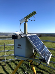
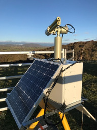
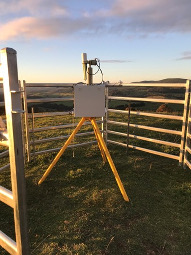
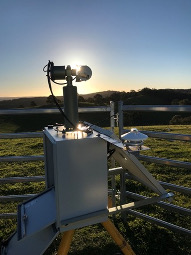
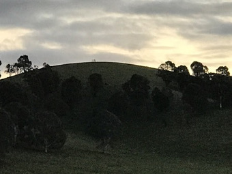
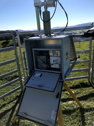
Site is located at the top of a hill in a pasture on a farming property at 351 Dunbritton Road, Courabyra NSW. The site is approximately 5 km west of the town of Courabyra and 10 km northwest of the town of Tumbarumba in the Western Snowy Mountains.��The selected site allows for unobstructed views of the horizon.��A study 1.8 m fence has been constructed around the site to prevent bovine ingress.��The rural area is located near large expanses of eucalyptus woodland, which is logged for timber. Aerosols in the region may be sourced from wood burning for heating of farm houses in winter and burning off of forest in spring to reduce fuel loads, or wildfires in spring and summer.��The Robot is installed on an electrical control box, which sits atop of a custom tripod. A pyranometer is installed to the east of the robot. An 80W solar panel charges a 35 Ah gel 12v battery. Inside the electrical control box is a smaller electrical control box containing the battery, solar charge controller and Cimel CE318-T control box. The Cimel CE318-T installed has the Aeronet number 969.
|
| Contact Information |
|
Principal Investigator(s):
|
- Ian Lau
- E-mail: ian.lau@csiro.au
Ian Lau
CSIRO Mineral Resources
26 Dick Perry Avenue
Kensington, Western Australia
Australia. (Post code) 6151
Phone is +61 86436 8646
Email: ian.lau@csiro.au
|
|
Co-Investigator(s)
Information
|
- David Barker
- E-mail: david.barker@csiro.au
David Barker
CSIRO Environment
107-121 Station Street
Aspendale, Victoria,
Australia (postcode) 3195
Ph: +61-3-92394450
Email: david.barker@csiro.au
|
|
Site Manager(s):
|
- James Bremner
- Email:
-
James Bremner (Property owner)
351 Dunbritton Road
Courabyra NSW
Tel: +61 427710429
|
|
Responsible
Institution(s):
|
|
|
Email Amy Scully
for content and picture updates.
Last Generated: 18 MAY 2024
|