|
|
 |
AERONET Site Information Database
Site Index
|
|

|
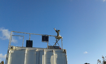
Image
1 - view of the sun photometer |
| Image
2 - view of the sun photometer |
|
Image 1
|
Image 2
|
|
|
Site Coordinates and Elevation:
|
- Latitude: 36.84278° South
- Longitude: 73.02531° West
- Elevation: 170.0 Meters
|
|
Site
Description:
|
- The CIMEL photometer will be located on the tower close to the roof of the LIDAR-CEFOP observatory facility, located at 36°50´ S, 7°01´ W, 2.5 km from University of Concepcion Campus and 170 amsl. This is the cleanest place in the city, located far away from direct emissions of industrial zone. Straight-line approximated distances from LIDAR-CEFOP Observatory to Bio Bio river and to the coast of Pacific Ocean are 2,8km and 11,6km, respectively.
|
|
Principal
Investigator(s)
Information:
|
- Pawan Gupta
- E-mail: Pawan.Gupta@nasa.gov
- Code 618 Building 33
NASA Goddard Space Flight Center
Greenbelt,MD 20771 USA
Ph: 256-961-7913
Fax: 1-301-614-6695
- Elena Lind
- E-mail: Elena.Lind@nasa.gov
- Code 618, Building 33
NASA Goddard Space Flight Center
Greenbelt,MD 20771 USA
Ph: 301-614-0362
Fax: 1-301-614-6695
|
|
Site
Manager(s) Information:
|
|
|
Responsible
Institution(s):
|
-
Center For Optics and Photonics (CEFOP),Universidad de Concepcion
www.cefop.cl
|
|
Email Amy Scully
for content and picture updates.
Last Generated: 9 MAY 2024
|