|
|
 |
Back to Map
Wallops (Wallops Island, Virginia)
|
Coordinates:
37.93285° N,
75.47195° W
Elevation: 37.0 m
|
Site Description
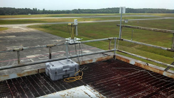
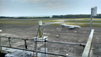
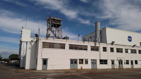
The instrument is mounted on the platform of an old radar tower located on top of an aircraft hangar at the NASA GSFC Wallops Flight Facility. This site is situated ~2 km from Chincoteague Bay and ~15 km from the Atlantic Ocean to the east and ~25km from the Chesapeake Bay to the west. Agriculture activities are prominent along the Virginia Eastern Shore of the Delmarva peninsula.�**When accessing the tower for maintenance, stay on the metal grinding of the tower and stay off the wooden covers on the top level of the tower
|
| Contact Information |
|
Principal Investigator(s):
|
- Pawan Gupta
- E-mail: pawan.gupta@nasa.gov
-
Pawan Gupta
NASA Goddard Space Flight Center
Code 618. Bldg.33. Rm.G412
Greenbelt, MD. 20771
Tel: 301-614-6658
Email: pawan.gupta@nasa.gov
- Elena Lind
- E-mail: elena.lind@nasa.gov
-
Elena Lind
NASA Goddard Space Flight Center
Code 618. Bldg.33. Rm.G414
Greenbelt, MD 20771
Tel: 301-614-6629
Email: elena.lind@nasa.gov
|
|
Site Manager(s):
|
- Jim Yungel
- Email: james.k.yungel@nasa.gov
-
Jim Yungel
Wallops Flight Facility
Bldg N-159, Room E203
Wallops Island, VA, 23337
Phone: 757-824-1060; Fax: 757-824-1036
E-mail: james.k.yungel@nasa.gov
AND
- Matt Linkswiler
- Email: Matthew.A.Linkswiler@nasa.gov
-
Matt Linkswiler
NASA / Wallops Flight Facility
Bldg N-159, Room E203
Wallops Island, VA 23337
Phone: 757-824-1020
Email: Matthew.A.Linkswiler@nasa.gov
|
|
Responsible
Institution(s):
|
|
|
Email Amy Scully
for content and picture updates.
Last Generated: 18 MAY 2024
|