|
|
 |
AERONET Site Information Database
Site Index
|
|
|
Image
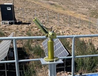
1 - CIMEL #1287 photometer measuring at Yerba Loca site in March 2022. |
| Image
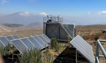
2 - Yerba Loca site in March 2022. |
|
Image 1
|
Image 2
|
|
|
Site Coordinates and Elevation:
|
- Latitude: 33.33015° South
- Longitude: 70.29650° West
- Elevation: 2715.0 Meters
|
|
Site
Description:
|
- Yerba Loca is a protected natural park over the Andes Mountains, about 40 km East of Santiago (a metropolis of 6 million inhabitants). Seasonal snow in the park is sensitive to Black Carbon (BC) deposition from fossil fuel and biomass combustion in Santiago. BC darkens the snow surface, reduces the albedo, and accelerates melting. These particles can be transported by near-surface winds flowing from the valleys west of the Andes towards the mountains The photometer has been set up at an atmospheric station aimed at monitoring the transport of aerosols from Santiago to the Andes Mountains.
|
|
Principal
Investigator(s)
Information:
|
- Raul R. Cordero
- E-mail: raul.cordero@usach.cl
Dr. Raul R. Cordero
Departamento de Física
Universidad de Santiago de Chile
Rosario Norte 399, Las Condes
Santiago Chile
Tel: +56 9 97352030
Email: raul.cordero@usach.cl
|
|
Site
Manager(s) Information:
|
|
|
Responsible
Institution(s):
|
-
University of Santiago, Chile (USACH)
www.usach.cl
www.antarctica.cl
|
|
Email Amy Scully
for content and picture updates.
Last Generated: 10 MAY 2024
|