|
|
 |
| |
| OCEAN COLOR |
| |
| |
The Aerosol Robotic Network (AERONET), developed to sustain atmospheric studies at various scales with measurements from worldwide distributed autonomous sun-photometers has been extended to support marine applications. This new network component called AERONET – Ocean Color (AERONET-OC), provides the additional capability of measuring the radiance emerging from the sea (i.e., water-leaving radiance) with modified sun-photometers installed on offshore platforms like lighthouses, oceanographic and oil towers. AERONET-OC is instrumental in satellite ocean color validation activities through standardized measurements a) performed at different sites with a single measuring system and protocol, b) calibrated with an identical reference source and method, and c) processed with the same code.
A complete description of the methods and algorithms used to produce the normalized water leaving radiance are detailed in Zibordi et al. (IEEE Transactions in Geoscience and Remote Sensing 42: 401-415, 2004)". This paper is available at the AERONET Ocean Color Publications web page.
|
| |
| System Description |
| |
| |
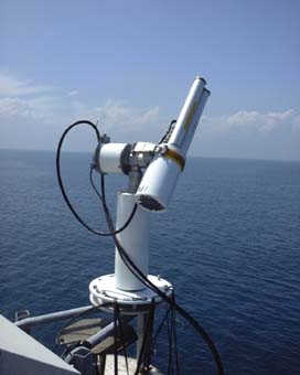
Recent developments in above water radiometry (Mobley 1999, Hooker et al. 2002, Zibordi et al. 2002) led to the development of a fully autonomous above-water radiometer system (Zibordi et al. 2004). This is based on the extended capability of CIMEL (Paris, France) CE-318 automated sun-photometers to perform marine radiometric measurements for determining the spectral Normalized Water-Leaving Radiance, Lwn(λ), in addition to the regular measurements for retrieving aerosol optical properties. This CIMEL-based system, called SeaWiFS Photometer Revision for Incident Surface Measurements (SeaPRISM), performs multiple sky- and sea-radiance measurements at programmable viewing and azimuth angles at eight (nine in the most recent instrument release) center-wavelengths in the 412-1020 nm spectral range.
The most recent SeaPRISM system configuration performs ocean color measurements at the 412, 443, 488, 531, 551 and 667 nm center-wavelengths. Additional measurements are performed at 870 and 1020 nm for quality checks, turbid water flagging, and for the application of alternative above-water methods (Zibordi et al. 2002). These center-wavelengths and additionally that at 940 nm were selected to guarantee basic AERONET atmospheric aerosol and water vapor monitoring capabilities and to support essential validation activities for current ocean color EO systems
|
| |
| Deployment Recommendations |
| |
| |
The following recommendations are provided for deployment of the SeaPRISM instrument:
- the deployment structure should be located more than five (5) nautical miles from the coast
- the deployment structure should be located in water deep enough to minimize the bottom effects [the bottom effects depend on the diffuse attenuation coefficient (Kd) and the irradiance reflectance (R)]
- the deployment location should be in the upper, most western part of the structure
- the deployment location should be on a dedicated platform extending approximately three (3) meters beyond the main structure
- the deployment location and structure should minimize sea spray effects
|
| |
| Version |
| |
| |
The AERONET Version 2 algorithm is used for the direct sun measurements. The normalized water-leaving radiance algorithm is at the base level, Version 1.
|
| |
| Quality Levels |
| |
| |
Normalized water-leaving radiances (Lwn) are provided in three levels: Level 1.0, 1.5, and 2.0. Level 1.0 data includeLwn determined from sequences of sea measurements taken with viewing geometries minimizing the platform perturbations. Level 1.5 data include screen Lwn corresponding to Level 1.0 products from measurement sequences not affected by a) cloud perturbations as determine from direct sun irradiance measurements, b) high variability in sea observations indicating elevated wave perturbations, or c) high Lwn values in the near infrared suggesting the presence of obstacles in the optical path between the instrument and the water surface. Level 2.0 data refer to fully quality-assured Lwn, corresponding to a) Level 1.5 products originated from SeaPRISMs exhibiting differences smaller than 5% between the calibration coefficients determined before and after typical one-year deployment periods, b) coincident aerosol optical depth of Level 2.0, and c) quality-assured statistical assessment according to the algorithm described by D'Alimonte and Zibordi 2006 (PDF). |
| |
|
