Skip all navigation and jump to content Jump to site navigation Jump to section navigation.
NASA Logo - Goddard Space Flight Center + Visit NASA.gov region to select the NASA home page region to select the NASA GSFC home page
Aerosol Robotic Network (AERONET)
AEROSOL OPTICAL DEPTH AEROSOL INVERSIONS SOLAR FLUX OCEAN COLOR Maritime Aerosol Network
For receiving updates on AERONET - subscribe to the mailing list by sending an email to aeronet-join@lists.nasa.gov

 +Home


Aerosols
AEROSOL/FLUX NETWORKS
CAMPAIGNS
COLLABORATORS
DATA
LOGISTICS
NASA PROJECTS
OPERATIONS
PUBLICATIONS
SITE INFORMATION
STAFF
SYSTEM DESCRIPTION
 
AERONET DATA ACCESS
 
AERONET Site Lists (V3)

+ Text Format

+ Google Earth Format

+ All Lists


FIELD CAMPAIGN -
Distributed Regional Aerosol Gridded Observation Networks (DRAGON)-USA
2012-2013 San Joaquin Valley (California)


Updates
Instrument Status Log
Summaries
Additional DISCOVER-AQ Links
 
DRAGON-USA CA SJV (Latest GIF | Latest PDF | Archive)
 
Data (Top)
 

Aerosol Optical Depth Products (including water vapor and fine/coarse mode AOD)

+ AOD Data Browser

+ AOD Data Download Tool

Almcuantar Inversion Aerosol Properties (including size distributions, complex index of refraction, single scattering albedo, etc.)

+ Inversion Data Browser

+ Inversion Data Download Tool

Combined Data Download Table (November 1, 2012 to April 1, 2013)

Data
Data Format
Level 1.0 Aerosol Optical Depth (AOD)

+ All Points
+ Daily Averages
+ Monthly Averages

Level 1.5 Aerosol Optical Depth (AOD)
Level 2.0 Aerosol Optical Depth (AOD)
Level 1.0 Spectral Deconvolution Algorithm (SDA) Retrievals
Level 1.5 Spectral Deconvolution Algorithm (SDA) Retrievals
Level 2.0 Spectral Deconvolution Algorithm (SDA) Retrievals
Level 1.5 Almucantar Inversion Products
(except Phase Functions)
Level 1.5 Almucantar Inversion Products Phase Functions
Level 2.0 Almucantar Inversion Products
(except Phase Functions)
Level 2.0 Almucantar Inversion Phase Functions
 
Background
 

Aerosol measurement observations from ground-based sun photometers and sun/sky radiometers have played a critical role in developing, reformulating and validating satellite algorithms to characterize aerosol optical depth, modal aerosol retrievals and single scattering albedo among other parameters.   New and improved algorithms are being developed for current and future satellite missions that will place a greater demand on the accuracy and fidelity of the ground-based measurements for validation, multi data set synergism and long-term climate research.  Heretofore satellite validation studies using sun and sky scanning spectral radiometer measurements such as AERONET have relied on point observations extrapolated to a two dimensional domain to compare to the satellite retrieval.  Additionally few of the ground-based remote sensing measurements have had a rigorous comparison or validation against other ground-based measurements particularly in situ observations of aerosol size and absorption.  DRAGON-USA will provide a data set to address satellite validation and in situ comparisons.

+ DRAGON White Paper

 
Experimental Objectives (Top)
 
  • Establish a mesoscale gridded network of sun photometers that encompasses, urban, agricultural and mountain landscapes over the San Joaquin Valley of California
  • Optimize the grid to validate/collaborate inversion products in conjunction with aircraft flights performing in situ measurements
  • Optimize the gridded network to validate satellite retrievals from 50 m to 10 Km pixel resolution
  • Supplement the gridded network with non gridded sites to capture aerosol variability
  • Develop a geo-referenced database that will accommodate supplementary/complimentary data sets
 
Measurement Plan (Top)
 

The campaign will be implemented under the NASA-funded Earth Venture airborne mission, DISCOVER-AQ (Deriving Information on Surface Conditions from Column and Vertically Resolved Observations Relevant to Air Quality). The campaign will employ NASA aircraft to make a series of flights, with scientific instruments on board to measure gaseous and particulate pollution, during a month period beginning in mid-January 2013 in the San Joaquin Valley of California. The distribution encompasses a 250 km long by 100 km wide region.

DRAGON-USA 2012-2013 instrument deployments will occur in and around the San Joaquin Valley of California (Figure 1) with approximately fifteen regionally distributed instruments.

Figure 1 DRAGON-USA 2012 Site Distribution

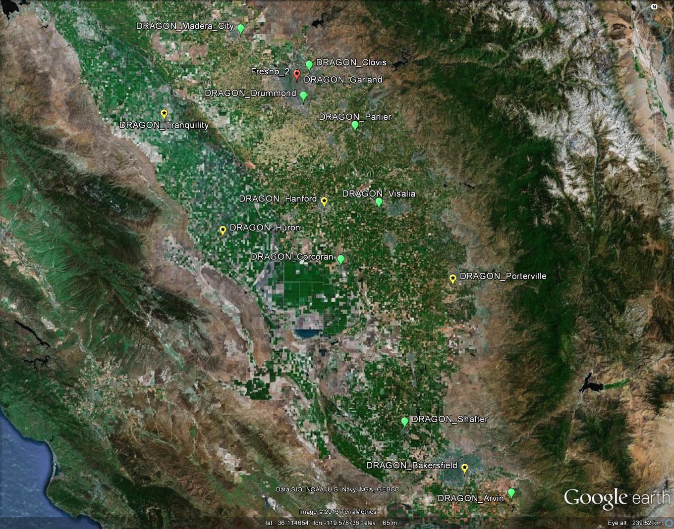
Figure 1. DRAGON-USA 2012-2013 Site Distribution Download KMZ file.

DRAGON Text Lists

+ Level 1.0 AOD Data (TXT)
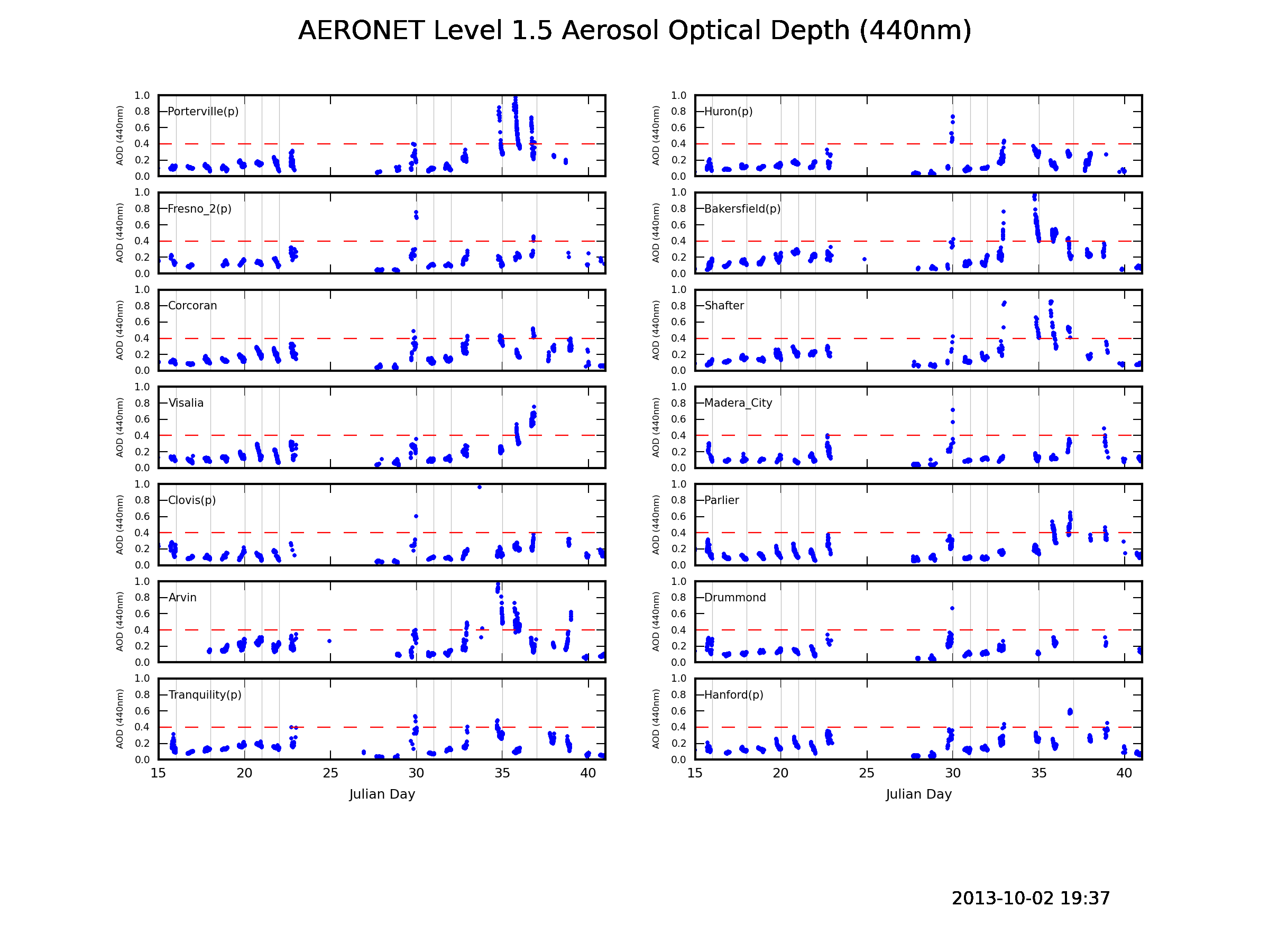
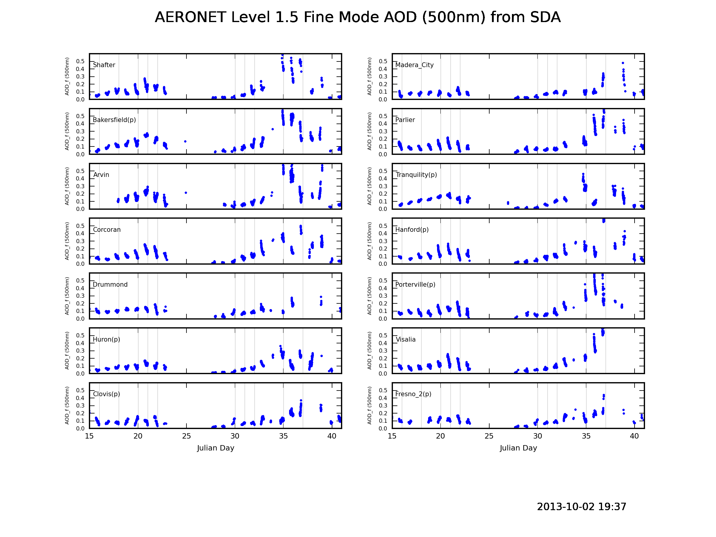
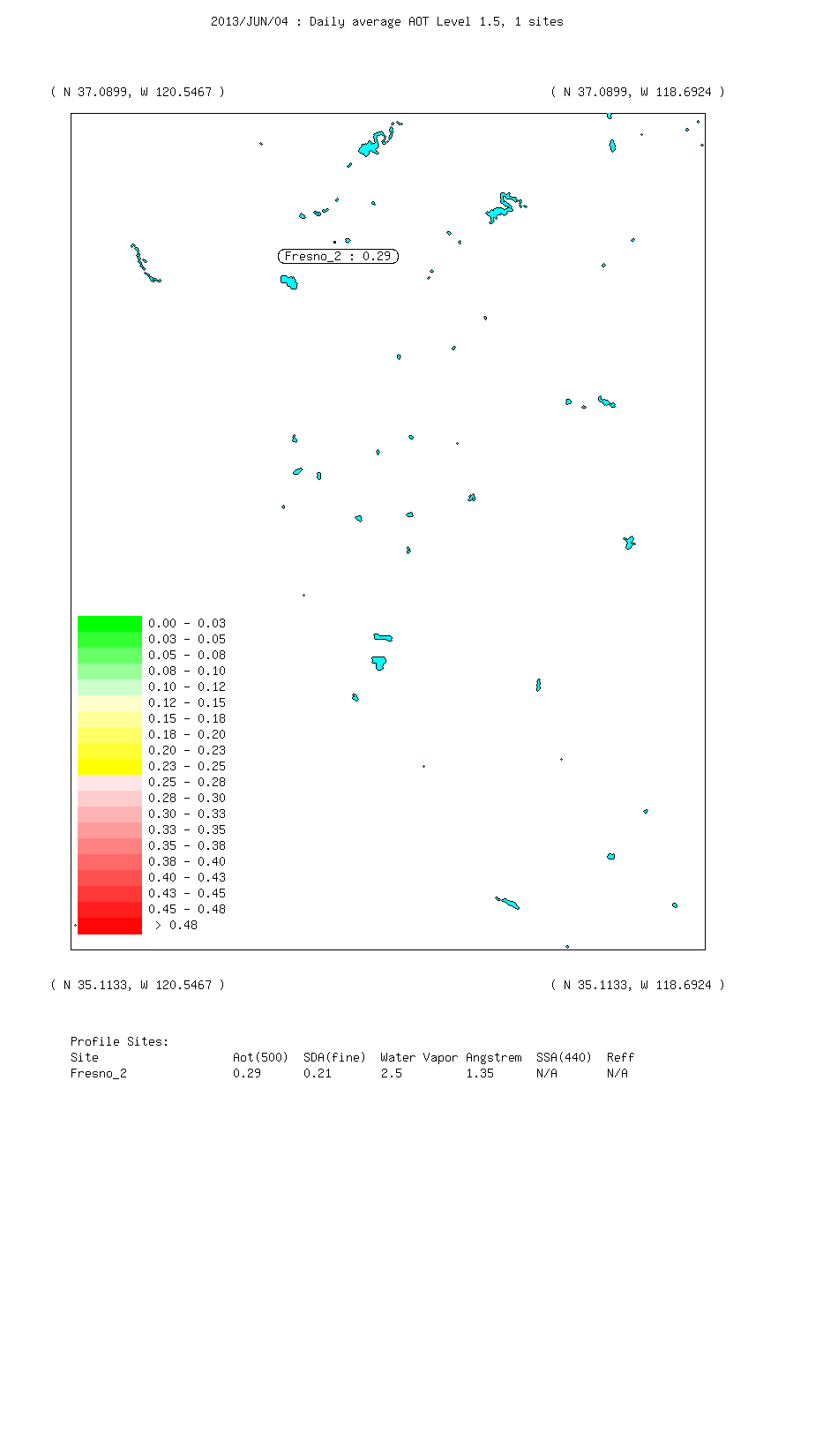
+ Level 1.5 AOD Data
(TXT)
+ Level 2.0 AOD Data (TXT)

DRAGON Google Earth Distribution

+ Level 1.0 AOD Data (Google Earth KMZ)
+ Level 1.5 AOD Data
(Google Earth KMZ)
+ Level 2.0 AOD Data (Google Earth KMZ)

 
Contacts (Top)
Collaborators
Title/Project Organization
Brent Holben
AERONET PI
NASA GSFC
Joel Schafer
AERONET
NASA GSFC
James Crawford
DISCOVER-AQ PI
NASA LaRC
Ken Pickering
DISCOVER-AQ, Deputy PI
NASA GSFC
Jay Herman
PANDORA
UMBC
Ihab Abboud
AEROCAN
Environment Canada
Rich Ferrare
HSRL
NASA LaRC
Judd Welton
MPLNET
NASA GSFC
Bruce Anderson
P-3B: LARGE (aerosols)
NASA LaRC
Anne Thompson
NATIVE
Pennsylvania State University
Richard Clark
Tethered Balloon
Millersville University
Nathan Travino
California Air Resources Board
California EPA
     
Tom Eck
AERONET
NASA GSFC
Mikhail Sorokin
AERONET
NASA GSFC
David Giles
AERONET
NASA GSFC
Ilya Slutsker
AERONET
NASA GSFC
Peter Kenny
AERONET
NASA GSFC
Alexander Smirnov
AERONET
NASA GSFC
Jon Rodriguez
AERONET
NASA GSFC
Aliaksandr Siniuk
AERONET
NASA GSFC
Amy Scully
AERONET
NASA GSFC


  + Privacy Policy and Important Notices NASA Curator: Ilya Slutsker
NASA Official: Pawan Gupta
Last Updated: March 28, 2017