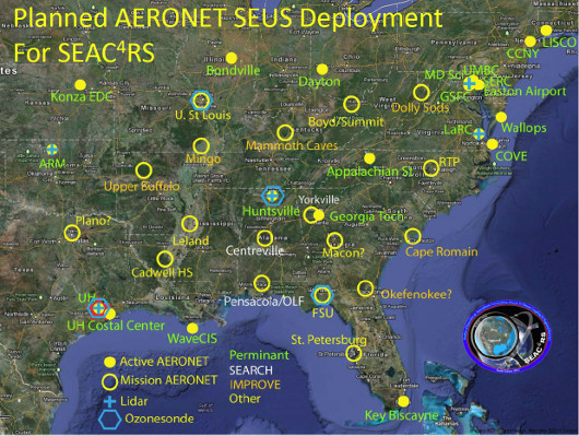
In support of the NASA Studies of Emissions and Atmospheric Composition, Clouds and Climate Coupling by Regional Surveys (SEAC4RS), ~15 AERONET sites will be established across the Southeast United States to provide the first coherent regional ground network of sun photometer data. Many of the new sites will be setup in collaboration with IMPROVE, SEARCH, and US EPA NERL as well as participating schools and universities.
In August and September 2013, the NASA DC-8 and ER-2 aircraft will fly over the continental US to investigate the influence of biomass burning smoke and pollution, their temporal evolution, and impacts on meteorological processes and feedbacks into regional air quality. Aircraft sampling regions are anticipated over the western and southeast United States. SEAC4RS activities will dovetail with DRAGON-USA Houston where 15 AERONET instruments deployed in the Houston, Texas metropolitan region to the Gulf of Mexico in support of NASA DISCOVER-AQ P3-B and King Air air quality research flights occurring in September 2013.

Figure 1. SEAC4RS Southeast US 2013 Site Distribution
DRAGON Text Lists
+ Level 1.0 AOD Data (TXT)
+ Level 1.5 AOD Data (TXT)
+ Level 2.0 AOD Data (TXT)
DRAGON Google Earth Distribution
+ Level 1.0 AOD Data (Google Earth KMZ)
+ Level 1.5 AOD Data (Google Earth KMZ)
+ Level 2.0 AOD Data (Google Earth KMZ)
|