|
|
 |
AERONET Site Information Database
Bozeman (Bozeman, Montana)
Site Index
|
|

|
Image
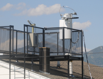
1 - Montana State University instrument in Bozeman, Montana, with the Bridger Mountains in the background. |
| Image
2 - Montana State University instrument on its rooftop mount in Bozeman, Montana. |
|
Image 1
|
Image 2
|
|
|
Site Coordinates and Elevation:
|
- Latitude: 45.66220° North
- Longitude: 111.04501° West
- Elevation: 1507.0 Meters
|
|
Site
Description:
|
- The instrument is mounted on the top of the south penthouse on the roof of Cobleigh Hall on the Montana State University campus on the south side of Bozeman, Montana.
|
|
Principal
Investigator(s)
Information:
|
- Joseph A. Shaw
- E-mail: jshaw@montana.edu
-
Dr. Joseph A. Shaw, Professor
Montana State University
Electrical & Computer Engineering Department
610 Cobleigh Hall
Bozeman, MT 59717
Ph. 406-994-7261
Fax 406-994-5958
Email:jshaw@montana.edu
AND
- Kevin Repasky
- E-mail: repasky@ece.montana.edu
-
Dr. Kevin Repasky, Assistant Professor
Montana State University
Electrical & Computer Engineering Department
610 Cobleigh Hall
Bozeman, MT 59717
Ph. 406-994-6082
Fax 406-994-5958
Email: repasky@ece.montana.edu
|
|
Site
Manager(s) Information:
|
- Joseph A. Shaw
- Email: jshaw@montana.edu
-
Dr. Joseph A. Shaw, Professor
Montana State University
Electrical & Computer Engineering Department
610 Cobleigh Hall
Bozeman, MT 59717
Ph. 406-994-7261
Fax 406-994-5958
Email:jshaw@montana.edu
|
|
Responsible
Institution(s):
|
-
Montana State University - Bozeman (with research funding from NASA)
|
|
Email Amy Scully
for content and picture updates.
Additional Photographs and Images
| CAPTION | IMAGE |
|---|
|
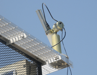
Image 3 - Close-up view of the Montana State University instrument on its rooftop mount in Bozeman, Montana.
| 
|
|
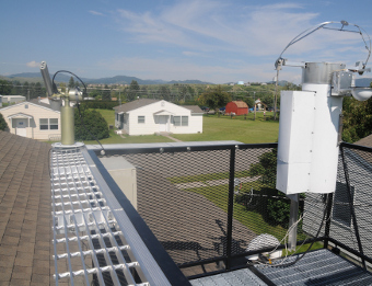
Image 4 - Montana State University AERONET instrument (left) and all-sky polarization imager (right) on rooftop platform in Bozeman, Montana.
| 
|
Last Generated: 28 MAY 2024
|