|
|
 |
| |
|
| |
About AERONET
The AERONET (AErosol RObotic NETwork) program is a federation of ground-based remote sensing aerosol networks established by
NASA and PHOTONS
(PHOtométrie pour le Traitement Opérationnel de Normalisation Satellitaire; Univ. of Lille 1,
CNES, and CNRS-INSU) and is greatly expanded by networks, calibration centers,
and collaborators (e.g., RIMA,
AeroSpan, APAC,
AEROCAN, AEROSPAIN,
NEON, and CARSNET)
from national agencies, institutes, universities, individual scientists,
and partners. For more than 25 years, the project has provided long-term,
continuous, and readily accessible public domain database of aerosol optical,
microphysical and radiative properties for aerosol research and characterization, validation of satellite retrievals,
and synergism with other databases. The network imposes standardization of instruments,
calibration, processing and
distribution.
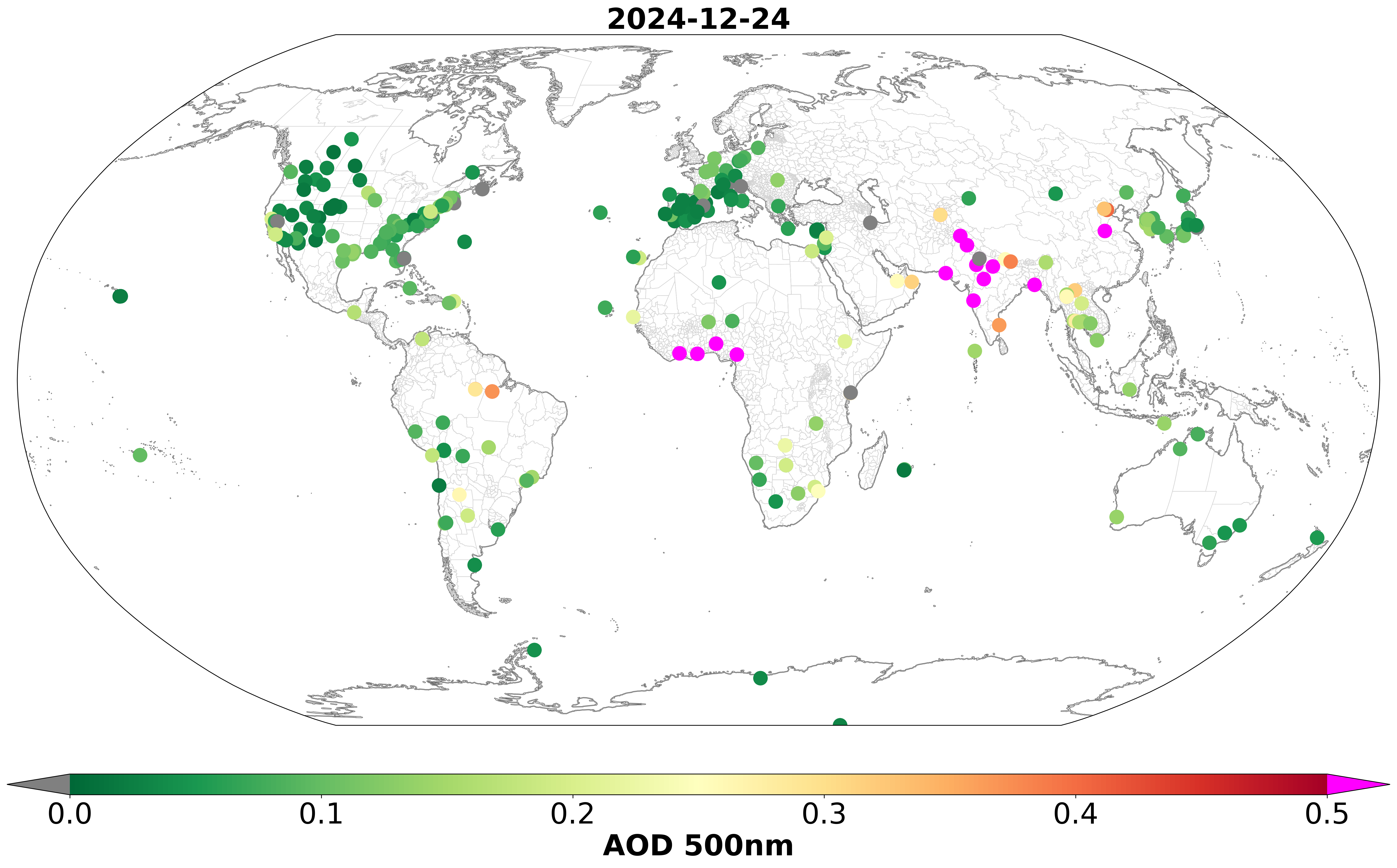
AERONET collaboration provides globally distributed observations of spectral aerosol optical depth (AOD),
inversion products, and precipitable water in diverse aerosol regimes.
Version 3 AOD data are computed for three data quality levels: Level 1.0 (unscreened),
Level 1.5 (cloud-screened and quality-controlled), and Level 2.0 (quality-assured). Inversions, precipitable water, and other
AOD-dependent products are derived from these levels and may implement additional quality checks.
The AERONET - Ocean Color (AERONET-OC) is another component of the AERONET program,
provides the additional capability of measuring the radiance emerging from the sea (i.e.,
normalized water-leaving radiance) with sun-photometers installed on offshore platforms like lighthouses,
oceanographic and oil towers.
Similarly, the Maritime Aerosol Network (MAN)
component of the AERONET program provides ship-borne aerosol
optical depth measurements from the Microtops II sun photometers.
These instruments have been deployed periodically on ships of opportunity and research vessels
to monitor aerosol properties over the World's Oceans.
The Solar Radiation Network (SolRad-Net) provides high-frequency solar
flux measurements and is collocated with AERONET sites.
The processing algorithms have evolved from Version 1.0 to Version 2.0 and now Version 3.0.
The Version 3 databases are available from the AERONET and PHOTONS web sites.
Version 2 data may be downloaded from the web site through 2018 and thereafter upon special request.
New AERONET products will be released as new measurement techniques and algorithms are adopted and validated by the AERONET research community.
The AERONET website also provides AERONET-related news, a description of research and operational activities, data visualization,
web services, related Earth Science links, and an AERONET staff directory.
+ Read More
|
| |
|
|
| |
|
|
| |
22 May 2026
AERONET Collaborative Research Instrument Loan Initiative |
| |
|
NASA AERONET is excited to announce the collaborative opportunity to make aerosols measurements through an instrument loan Initiative, a program offering short-term loans of calibrated AERONET instruments. As part of this collaborative research effort, NASA will provide the instrument free of cost; however, the host institution is responsible for logistical support, shipping, and maintenance of the instrument during its operation.
The initiative is designed to expand aerosol and atmospheric monitoring by deploying retired yet reliable Cimel sun photometers for periods of 3 to 24 months. In addition to supporting ongoing research, this loan program can be utilized to facilitate field campaigns, enable short-term data collection efforts, or address specific aerosol data needs in a particular location or region.
Please note that the pool of available instruments is limited, and preference will be given to institutions with mutual interested and located in U.S. states and territories. This opportunity supports scientific advancement, enhances data coverage - especially in underserved regions - and encourages cost-effective expansion of the monitoring network, while fostering collaborative research, training, and innovation. Institutions, groups, or individuals interested in participating are encouraged to contact AERONET PI Pawan Gupta for further details.
|
| |
3 April 2026
Launch of AERONET Site Monitoring Tool |
| |
|
We are excited to announce the launch of a new tool aimed at assisting site Principal Investigators and managers in effectively diagnosing and maintaining the health and data quality of sun photometers throughout the AERONET network.
This platform was developed to improve visibility into instrument performance, particularly for site teams who do not have direct access to internal raw data systems. By bridging this gap, the tool provides a clearer, more transparent view of how instruments are operating and how data quality is being assessed. At its core, the tool features an interactive map interface with filtering capabilities to assist with identifying instruments of interest. The platform includes a collection of resources to assist with routine operations and troubleshooting. These resources include setup documentation, preventive maintenance guides, parts lists, and system logs.
While this represents a significant addition, it addresses long-standing needs for accessibility, consistency, and transparency in instrument monitoring. The goal is to better equip site and PIs and managers with the information they need to maintain instrument performance and ensure high-quality data across the network. We encourage all site PIs and managers to explore the tool and incorporate it into their regular workflows.
|
| |
7 July 2025
Explore Diurnal Variability in AERONET Data |
| |
|
This tool evaluates the diurnal cycle of aerosol optical depth (AOD) using AERONET measurements, building upon the methodology of Smirnov et al. (2002). Unlike the previous approach that used percentage departures from daily averages, we now use absolute departures of individual measurements from daily means. We only include days with more than ten measurements to ensure sufficient data representation, as measurement protocols and meteorological conditions often lead to varying numbers of inputs for hourly bins. Our enhanced averaging technique implements a two-step process: first, differences are averaged for each hourly bin within each day; then, these daily hourly averages are combined to compute overall hourly means for the entire period. This approach creates more uniform contributions to each hourly slot and avoids sharp fluctuations in hourly inputs. It's worth noting that both magnitude and percentage methods yielded similar patterns and would lead to the same conclusions, but we selected the absolute difference approach for its robustness. Additional examples of this methodology can be found in Smirnov et al. (2024).
|
| |
27 June 2025
Level 2, Version 3, Nighttime Data Release |
| |
|
The Lunar AOD product relies on the Robotic Lunar Observatory (ROLO) Lunar Irradiance Model for extraterrestrial spectral irradiance, and this model requires additional corrections to produce an input that allows for lunar AOD calculations of maximum accuracy.
The AERONET approach to generate this spectral ROLO correction is based on comparing Vo's (top-of-the-atmosphere irradiance) of high elevation lunar Langleys with solar Langleys at both Mauna Loa Observatory (MLO) and Izaña Observatory calibration facilities. For a given instrument, the solar to lunar Vo ratios should match the sun/sky gain ratio of 4096. Thus, observed deviations from this nominal value could be determined as a function of lunar phase angle (LPA) and used as an empirical correction factor by which the base ROLO irradiances are modified.
The applied adjustment (empirical correction) to the lunar irradiance predicted by the ROLO model can often be relatively large (~10%) so it's critically important to examine the resulting AOD product for potential calibration bias. For this purpose, the most straightforward standard of comparison is with the associated solar AOD for the same instrument. While the sun and moon measurement periods are mutually exclusive, the transition interval from day to night (constrained by AOD stability checks) and vice versa provides an opportunity to quantify differences in this relatively short time window for hundreds of sites on a large set of suitable days.
For every wavelength, the mean AOD differences for all sites combined across the transition from day-night (night-day) were observed to be negligibly small for all wavelengths from 440 to 1640 nm (mean differences <= 0.0005) and similar or smaller than the mean differences observed within day or night periods for a comparable time gap. Likewise, site-specific averages for this transition period AOD difference between solar and lunar AOD were < 0.01 at all wavelengths for all sites.
While there are some operational aspects of the automated cloud-screening (aureole 'curvature check') during day time that are absent from the lunar AOD QC protocols due to a lack of moon aureole measurements, efforts to approximate this difference in protocol with solar data suggest the typical effect (if any) on nighttime AOD measurements is normally very small on a daily time scale and negligible on monthly statistics (further details in a paper in preparation). Note that there are seasonal intervals where decreases in Ångström exponent (presumably due to cloud contamination) are more pronounced and may be significant in some regions, such as southeast Asia often in association with monsoonal activity and stations in ITCZ affected regions. A small number of AERONET stations had 5-10% of the data record where day average Ångström exponent was found to be > 0.1 lower without the curvature check in this estimation.
Additionally, it's worth noting the vastly smaller signal at night (relative to solar signal) precludes AOD observations at UV wavelengths and prevents inversion measurements since sky radiance measurements are absent also due to insufficient signal. Based on this expansive assessment we find the lunar AOD dataset to be of high accuracy and without systematic bias throughout the full potential moon measurement interval (bright half of each lunar phase cycle) and suitable for L2 designation after post-deployment calibrations have been applied. The data is now available on the web for display or download.
|
| |
4 June 2025
New AERONET Data Download Guidelines |
| |
|
Dear AERONET colleagues and data users,
The AERONET website recently came to a halt due to a large volume of auto-generated download requests, and thus a limit was imposed to stabilize the system. We would like to inform all data users that some scripts, especially Python ones, have the capability of generating web hits very quickly, potentially slowing down and crashing the system if run by many users. The system will now throttle an IP/host that hits the same cgi-bin more than 10 times per minute. To avoid an IP block we recommend data users to consider the following suggestions for downloads:
- Try either limiting number of hits per minute or using consolidated requests. For example, instead of downloading data in site/day chunks, data for all sites can be downloaded in one request. This can be done by omitting the "site=sitename&" parameter in the URL, and it would download all sites for that day. In addition to that, a bounding box parameter (lat1,lon1,lat2,lon2) exists and can be included in the URL, which is useful when data from many sites from a particular region are needed.
- If more than one day of data are needed, the combinations day1, month1, year1, day2, month2, year2 can be modified to achieve that. For example, setting day1 = 1 and day2 = 31 will get all days in that particular month in one request, as opposed to having 31 separate requests. Similarly, setting month1 = 1, month2 = 12, day1 = 1, day2 = 31 will get an entire year worth of data in one request, as opposed to having 365 separate requests.
- The time limits to the whole year, or to any time period can also be used. For example, it is possible to download one site's data for its entire deployment history.
If you suspect your IP was blocked, please send an email to Ilya Slutsker. Please also visit the Download Tool Interface Help page to learn more about the web service parameters and data types. We appreciate your cooperation and support!
|
| |
| + More Announcements |
| |
|
| |